
The Texas drought is ongoing and severe. California is beginning to feel the effects in the San Joaquin Valley. Precipitation is a fraction of normal. Is severe drought coming to California and the West in 2012? Check out the Drought Monitor and Drought Impact Reporter Maps for more about this.
Mike Meuser
GIS Project Development, Data Research and Custom Shapefile Creation
Free GIS Software, Shapefiles, Maps and Tutorials
Free GPS, Aerial, TOPO Maps and News
If you have data, GIS project or custom shapefile needs send me an email
Premium Shapefiles: ZipCode, Indian & Federal Lands, School Districts, Tornadoes, Dams, Climate Change & Global Warming
Friday, December 30, 2011
Caliper's Maptitude 2012 On Its Way
Caliper corp. just released the latest Maptitude GIS 2012. Mine is on its way. As soon as I've had a chance to use it, I'll post a review. Maptitude has always been my GIS of choice for several reasons - affordability, ease of use, tons of free current data.... While you wait for the review you may want to check out Why We Use Maptitude GIS and new Maptitude 2012 features and bundled data.
Mike Meuser
GIS Project Development, Data Research and Custom Shapefile Creation
Free GIS Software, Shapefiles, Maps and Tutorials
Free GPS, Aerial, TOPO Maps and News
If you have data, GIS project or custom shapefile needs send me an email
Premium Shapefiles: ZipCode, Indian & Federal Lands, School Districts, Tornadoes, Dams, Climate Change & Global Warming
Wednesday, December 28, 2011
Sanctions on Iran Results in Iran blockading Strait of Humoz Reducing Fuel Flow from Middle East. Will This Fuel the Fire for U.S. Oil, Gas and Nuclear Energy?
It looks like were drawing ever closer to a war with Iran even though it is not clear at all whether or not Iran is actually building nuclear weapons. In response to increasing U.S. and European sanctions, Iran has threatened to blockade the Strait of Humoz. Around 13 loaded oil tankers travel through the Straits of Humoz each day. Oil and gas prices are already very high. What will this mean for the future? Perhaps those in the U.S. that are pushing for the Keystone XL project, drilling in the Arctic, fracking for natural gas, wrongly pushing for nuclear as a sustainable alternative and blowing off the tops of mountains for coal will see the threat of less oil flowing from the Middle East as a good thing. It will surely provide fuel for the fire of domestic oil, gas and nuclear energy production. Too bad that it won't, instead, fuel the fire for solar and other alternative energy technologies in the U.S. - the real solution to increasing domestic energy production, creating high paying jobs here in the U.S.

Here's a description from Wikipedia
The Strait of Hormuz is a narrow, strategically important strait between the Gulf of Oman in the southeast and the Persian Gulf. On the north coast is Iran and on the south coast is the United Arab Emirates and Musandam, an exclave of Oman.
The strait at its narrowest is 54 kilometres (34 mi) wide.[1] It is the only sea passage to the open ocean for large areas of the petroleum-exporting Persian Gulf. About 13 tankers carrying 15.5 million barrels (2,460,000 m3) of crude oil pass through the strait on an average day, making it one of the world's most strategically important choke points. This represents 33% of the world's seaborne oil shipments, and 17% of all world oil shipments in 2009.[2]...Read more at Wikipedia.
Source: Truthout
As US Readies Sanctions, Iran Threatens to Block Oil Route
Wednesday 28 December 2011
by: David E. Sanger, The New York Times News Service | Report
Washington - A senior Iranian official on Tuesday delivered a sharp threat in response to economic sanctions being readied by the United States, saying his country would retaliate against any crackdown by blocking all oil shipments through the Strait of Hormuz, a vital artery for transporting about one-fifth of the world’s oil supply.
The declaration by Iran’s first vice president, Mohammad-Reza Rahimi, came as President Obama prepares to sign legislation that, if fully implemented, could substantially reduce Iran’s oil revenue in a bid to deter it from pursuing a nuclear weapons program.
Prior to the latest move, the administration had been laying the groundwork to attempt to cut off Iran from global energy markets without raising the price of gasoline or alienating some of Washington’s closest allies.
Apparently fearful of the expanded sanctions’ possible impact on the already-stressed economy of Iran, the world’s third-largest energy exporter, Mr. Rahimi said, “If they impose sanctions on Iran’s oil exports, then even one drop of oil cannot flow from the Strait of Hormuz,” according to Iran’s official news agency. Iran just began a 10-day naval exercise in the area.
In recent interviews, Obama administration officials have said that the United States has developed a plan to keep the strait open in the event of a crisis. In Hawaii, where President Obama is vacationing, a White House spokesman said there would be no comment on the Iranian threat to close the strait. That seemed in keeping with what administration officials say has been an effort to lower the level of angry exchanges, partly to avoid giving the Iranian government the satisfaction of a response and partly to avoid spooking financial markets.
But the energy sanctions carry the risk of confrontation, as well as economic disruption, given the unpredictability of the Iranian response. Some administration officials believe that a plot to assassinate the Saudi ambassador to the United States — which Washington alleges received funding from the Quds Force, part of the Iranian Revolutionary Guards Corps — was in response to American and other international sanctions...Read more at Truthout
Related
World Energy Requirements Can Be Met With Renewables
Download Free Oil and Gas Reserves, Production and Exploration Maps
Free Iran Country, Cities and Places GIS Shapefile Map Layers
Download Free World Ethnicity & Religion Maps
Download Free Middle East Country Atlas Maps
Mike Meuser
GIS Project Development, Data Research and Custom Shapefile Creation
Free GIS Software, Shapefiles, Maps and Tutorials
Free GPS, Aerial, TOPO Maps and News
If you have data, GIS project or custom shapefile needs send me an email
Premium Shapefiles: ZipCode, Indian & Federal Lands, School Districts, Tornadoes, Dams, Climate Change & Global Warming
Wednesday, December 21, 2011
Interactive Maps: Billions Given to State and Local Law Enforcement for War on Terror
Interesting interactive maps. Look at the line items. Some are straightfoward but what is "non-profit security" and "operation stone garden?"

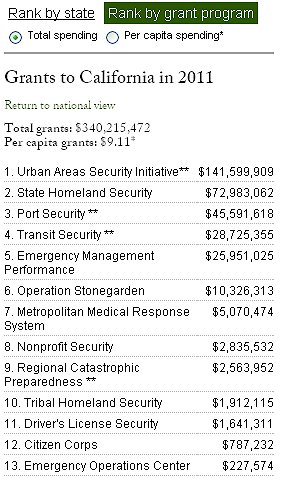
View Maps and Learn More
Mike Meuser
GIS Project Development, Data Research and Custom Shapefile Creation
Free GIS Software, Shapefiles, Maps and Tutorials
Free GPS, Aerial, TOPO Maps and News
If you have data, GIS project or custom shapefile needs send me an email
Premium Shapefiles: ZipCode, Indian & Federal Lands, School Districts, Tornadoes, Dams, Climate Change & Global Warming
Friday, December 16, 2011
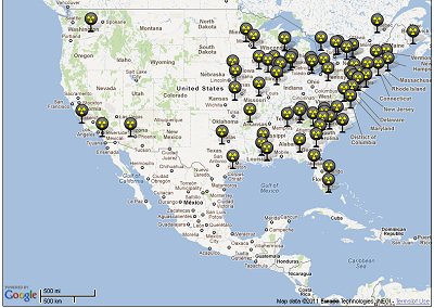
Do You Live Within 30 Miles of a Nuclear Power Plant? Maps of Evacuation Areas
Physicians for Social Responsibility Create Maps of Nuclear Accident Evacuation Zones in the U.S.
Though we hear little about the Fukushima nuclear accident in our mainstream media or from our government, the situation just keeps getting worse. Many more people were affected and continue to be affected by radiation. Crops and fields have been ruined... the list goes on and on. PSR has prepared a a press release that outlines lessons unlearned. See: Remembering "3/11": Six Months After the Fukushima Reactor Disaster, Key Lessons Appear to be Going Unlearned.
Here are a few screenshots. For more maps and information visit Nuclear Accident Evacuation Maps.


For more maps and information visit Nuclear Accident Evacuation Maps.
Mike Meuser
GIS Project Development, Data Research and Custom Shapefile Creation
Free GIS Software, Shapefiles, Maps and Tutorials
Free GPS, Aerial, TOPO Maps and News
If you have data, GIS project or custom shapefile needs send me an email
Premium Shapefiles: ZipCode, Indian & Federal Lands, School Districts, Tornadoes, Dams, Climate Change & Global Warming
Though we hear little about the Fukushima nuclear accident in our mainstream media or from our government, the situation just keeps getting worse. Many more people were affected and continue to be affected by radiation. Crops and fields have been ruined... the list goes on and on. PSR has prepared a a press release that outlines lessons unlearned. See: Remembering "3/11": Six Months After the Fukushima Reactor Disaster, Key Lessons Appear to be Going Unlearned.
Here are a few screenshots. For more maps and information visit Nuclear Accident Evacuation Maps.
For more maps and information visit Nuclear Accident Evacuation Maps.
Mike Meuser
GIS Project Development, Data Research and Custom Shapefile Creation
Free GIS Software, Shapefiles, Maps and Tutorials
Free GPS, Aerial, TOPO Maps and News
If you have data, GIS project or custom shapefile needs send me an email
Premium Shapefiles: ZipCode, Indian & Federal Lands, School Districts, Tornadoes, Dams, Climate Change & Global Warming
Sunday, December 4, 2011
List of World Shapefiles Now Available for Free Download
These are the country, city and place shapefiles in the new updated world shapefiles set. They are free to download and use as you wish subject to the Creative Commons Attribution Share-Alike 2.0 License.
Iraq
Palestine
Israel
Afghanistan
Iran
Pakistan
Burundi
Comoros
Djibouti
Each set contains the following:
* Files with 'highway' suffix describe country's highways in form of polylines and associated attributes - highway type, name, is highway oneway.
* Files with 'poi' suffix describe country's points of interest in form of points and associated attributes - name and type.
* Files with 'natural' suffix describe country's areas marked as woods, forests, parks, and water surfaces in form of polygons and their names and types.
* Files with 'administrative' suffix contain administrative boundaries including country's international boundaries.
* Files with 'location' suffix contain locations and addresses.
* Files with 'coastline' suffix contain osm coastline and water bodies extracts in form of polylines and their names.
* Files with 'water' suffix contain osm water bodies in form of polygons and their names.
I'll be adding a few a day until I've got them all done. If you have a request, be sure to let me know and I'll put it at the tops of the list.
Click here for the new world shapefiles
Mike Meuser
GIS Project Development, Data Research and Custom Shapefile Creation
Free GIS Software, Shapefiles, Maps and Tutorials
Free GPS, Aerial, TOPO Maps and News
If you have data, GIS project or custom shapefile needs send me an email
Premium Shapefiles: ZipCode, Indian & Federal Lands, School Districts, Tornadoes, Dams, Climate Change & Global Warming
Saturday, December 3, 2011
New Updated Series of World County, City and Place GIS Shapefiles
Free downloads of world country, city and place GIS shapefile map layers. This is a works in progress. Take a look and if you have a request, email me and let me know and I'll get it online as soon as possible.
Access the world country, city and place shapefiles
Mike Meuser
GIS Project Development, Data Research and Custom Shapefile Creation
Free GIS Software, Shapefiles, Maps and Tutorials
Free GPS, Aerial, TOPO Maps and News
If you have data, GIS project or custom shapefile needs send me an email
Premium Shapefiles: ZipCode, Indian & Federal Lands, School Districts, Tornadoes, Dams, Climate Change & Global Warming
Thursday, November 10, 2011
IAEA Claimed Iran "Weapons "Expert" Never Actually Worked on Nuclear Weapons At All
Read about the supposed "weapons expert" and download the full November 8, 2011 IAEA Report: Implementation of the NPT Safeguards Agreement and relevant provisions of Security Council resolutions in the Islamic Republic of Iran.
Mike Meuser
GIS Project Development, Data Research and Custom Shapefile Creation
Free GIS Software, Shapefiles, Maps and Tutorials
Free GPS, Aerial, TOPO Maps and News
If you have data, GIS project or custom shapefile needs send me an email
Premium Shapefiles: ZipCode, Indian & Federal Lands, School Districts, Tornadoes, Dams, Climate Change & Global Warming
Tuesday, October 25, 2011
Where are the Free Maps and Other Stuff?
Here's a little clarification about how to find the Free Maps and other Free GIS and Mapping Resources at MapCruzin.com.
I am writing this because recently, I received the following email from a subscriber to feeds from the MapCruzin Blog, mapcruzin.blogspot.com.
At first I couldn't quite figure out why this person couldn't find the free Syria maps that I was posting about. Then, I think, I figured it out. Bear with me if this is not a problem for you.
On our blog each title is linked to the respective blog page. This makes sense if you go directly to the blog because when you do so you will view a list of blog posts and clicking on the title brings you to the correct blog page. But, what this person may have missed is that within the text of the blog, there are links to the free maps download page at MapCruzin.com.
So, to correct this, I'll be sure to say "click here" and also spell out the url so folks see it as a link.
Second problem may be that perhaps not all people get their MapCruzin feed updates in html format. If they don't then the links just don't work at all. In this case I'll also spell out the url address so if need be folks can copy and paste the url into their browser and find the pages that way.
Also, please note that though 99% of the resource, including maps, GIS software, and GIS shapefiles, are free, there are a few GIS shapefiles that I've developed that are for sale.
Lastly, you can find links to the free maps and other resources at MapCruzin.com on the right side of each blog page and each page at MapCruzin.com has a menu near the top indicating all the different free things.
MapCruzin.com has been online since 1996. Over the ensuing 15+ years I have added many thousands of pages, maps, shapefiles, GIS software, tutorials and other resources. It might take a bit to hunt around (I'm always trying to find ways to organize it all better) but, in many cases, you'll find what you are looking for.
Here are some pertinent URLS:
Free Maps: www.mapcruzin.com/download-free-maps.htm
Free GIS Software: www.mapcruzin.com/free-gis-software-tools.htm
Free GIS Shapefiles: www.mapcruzin.com/download-free-arcgis-shapefiles.htm
Free TOPO Maps: www.mapcruzin.com/free-download-topo-maps.htm
Free Aerial/Satellite/Remote Sensing Images: www.mapcruzin.com/satellite-aerial-photos-maps/
Free GIS Tutorial: www.mapcruzin.com/free-learn-to-map-gis-tutorial-and-shapefile-atlas.htm
Free GPS Resources: www.mapcruzin.com/free-gps-maps-software/
Check this URL for the few GIS shapefiles for sale. Note that at this time ALL maps at MapCruzin.com are free.
GIS shapefiles for sale: www.mapcruzin.com/do-it-yourself-gis-maps-shapefiles/
MapCruzin Blog: mapcruzin.blogspot.com/
Hope this helps.
Mike Meuser
GIS Project Development, Data Research and Custom Shapefile Creation
Free GIS Software, Shapefiles, Maps and Tutorials
Free GPS, Aerial, TOPO Maps and News
If you have data, GIS project or custom shapefile needs send me an email
Premium Shapefiles: ZipCode, Indian & Federal Lands, School Districts, Tornadoes, Dams, Climate Change & Global Warming
I am writing this because recently, I received the following email from a subscriber to feeds from the MapCruzin Blog, mapcruzin.blogspot.com.
Hi map cruzin
why are you talking about downloading free maps and i cant find the maps? which free maps and your portal keeps taking me round and round to the same starting point. where are the maps? just tell us the truth. if the maps are free, then give then to me. if they are for sale then let me know the truth. dont keep on playing about with my brain. i need to know the truth or else i wont need any updates from you.
At first I couldn't quite figure out why this person couldn't find the free Syria maps that I was posting about. Then, I think, I figured it out. Bear with me if this is not a problem for you.
On our blog each title is linked to the respective blog page. This makes sense if you go directly to the blog because when you do so you will view a list of blog posts and clicking on the title brings you to the correct blog page. But, what this person may have missed is that within the text of the blog, there are links to the free maps download page at MapCruzin.com.
So, to correct this, I'll be sure to say "click here" and also spell out the url so folks see it as a link.
Second problem may be that perhaps not all people get their MapCruzin feed updates in html format. If they don't then the links just don't work at all. In this case I'll also spell out the url address so if need be folks can copy and paste the url into their browser and find the pages that way.
Also, please note that though 99% of the resource, including maps, GIS software, and GIS shapefiles, are free, there are a few GIS shapefiles that I've developed that are for sale.
Lastly, you can find links to the free maps and other resources at MapCruzin.com on the right side of each blog page and each page at MapCruzin.com has a menu near the top indicating all the different free things.
MapCruzin.com has been online since 1996. Over the ensuing 15+ years I have added many thousands of pages, maps, shapefiles, GIS software, tutorials and other resources. It might take a bit to hunt around (I'm always trying to find ways to organize it all better) but, in many cases, you'll find what you are looking for.
Here are some pertinent URLS:
Free Maps: www.mapcruzin.com/download-free-maps.htm
Free GIS Software: www.mapcruzin.com/free-gis-software-tools.htm
Free GIS Shapefiles: www.mapcruzin.com/download-free-arcgis-shapefiles.htm
Free TOPO Maps: www.mapcruzin.com/free-download-topo-maps.htm
Free Aerial/Satellite/Remote Sensing Images: www.mapcruzin.com/satellite-aerial-photos-maps/
Free GIS Tutorial: www.mapcruzin.com/free-learn-to-map-gis-tutorial-and-shapefile-atlas.htm
Free GPS Resources: www.mapcruzin.com/free-gps-maps-software/
Check this URL for the few GIS shapefiles for sale. Note that at this time ALL maps at MapCruzin.com are free.
GIS shapefiles for sale: www.mapcruzin.com/do-it-yourself-gis-maps-shapefiles/
MapCruzin Blog: mapcruzin.blogspot.com/
Hope this helps.
Mike Meuser
GIS Project Development, Data Research and Custom Shapefile Creation
Free GIS Software, Shapefiles, Maps and Tutorials
Free GPS, Aerial, TOPO Maps and News
If you have data, GIS project or custom shapefile needs send me an email
Premium Shapefiles: ZipCode, Indian & Federal Lands, School Districts, Tornadoes, Dams, Climate Change & Global Warming
Monday, October 24, 2011
Free Maps of Syria
Download Free High Resolution Maps of Syria - political, economy, landuse, population, damascus ... etc.
More Syria Maps and Neigboring Middle East Country Maps Here.
Mike Meuser
GIS Project Development, Data Research and Custom Shapefile Creation
Free GIS Software, Shapefiles, Maps and Tutorials
Free GPS, Aerial, TOPO Maps and News
If you have data, GIS project or custom shapefile needs send me an email
Premium Shapefiles: ZipCode, Indian & Federal Lands, School Districts, Tornadoes, Dams, Climate Change & Global Warming
Saturday, August 27, 2011
Download free Hurricane GIS Shapefile Map Layers
With hurrican Irene on its way. I thought some of you may be interested in these historical hurricane shapefiles. These cover the period from 1851 up to 2004. I'm working also to include more recent hurricanes in the near future.
The paths of tropical cyclones and major hurricanes from 1851 to 2004.
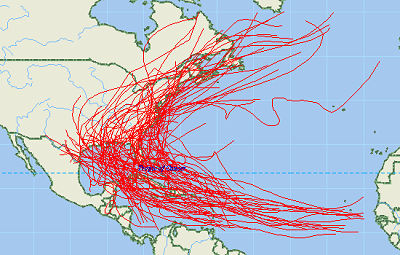
The term "tropical cyclone" is a generic term for a low-pressure storm system that usually forms in the tropics. The unpredictable behavior, high seas, and devastating winds of tropical storms have challenged us for centuries. One of our best defenses against hurricanes and other tropical storms is informed readiness. The National Hurricane Center (NHC), part of the National Oceanic and Atmospheric Administration, National Weather Service (NWS), collects tropical cyclone data as part of its mission to save lives and mitigate property loss by issuing advisories of hazardous tropical weather. The NHC tracks hurricanes and other tropical cyclones over the Atlantic, Caribbean, Gulf of Mexico, and Eastern Pacific and issues hurricane forecasts, watches, and warnings to the public. Computer models are used to forecast the track and intensity of a tropical storm. These statistical models use current information about a storm and compare it with historical knowledge about the behavior of similar tropical storms. The historical record for storms over the North Atlantic begins in 1851, and the record in the Pacific begins in 1949.
Download the free hurricane GIS shapefile map layers here
Mike Meuser
GIS Project Development, Data Research and Custom Shapefile Creation
Free GIS Software, Shapefiles, Maps and Tutorials
Free GPS, Aerial, TOPO Maps and News
If you have data, GIS project or custom shapefile needs send me an email
Premium Shapefiles: ZipCode, Indian & Federal Lands, School Districts, Tornadoes, Dams, Climate Change & Global Warming
The paths of tropical cyclones and major hurricanes from 1851 to 2004.
The term "tropical cyclone" is a generic term for a low-pressure storm system that usually forms in the tropics. The unpredictable behavior, high seas, and devastating winds of tropical storms have challenged us for centuries. One of our best defenses against hurricanes and other tropical storms is informed readiness. The National Hurricane Center (NHC), part of the National Oceanic and Atmospheric Administration, National Weather Service (NWS), collects tropical cyclone data as part of its mission to save lives and mitigate property loss by issuing advisories of hazardous tropical weather. The NHC tracks hurricanes and other tropical cyclones over the Atlantic, Caribbean, Gulf of Mexico, and Eastern Pacific and issues hurricane forecasts, watches, and warnings to the public. Computer models are used to forecast the track and intensity of a tropical storm. These statistical models use current information about a storm and compare it with historical knowledge about the behavior of similar tropical storms. The historical record for storms over the North Atlantic begins in 1851, and the record in the Pacific begins in 1949.
Download the free hurricane GIS shapefile map layers here
Mike Meuser
GIS Project Development, Data Research and Custom Shapefile Creation
Free GIS Software, Shapefiles, Maps and Tutorials
Free GPS, Aerial, TOPO Maps and News
If you have data, GIS project or custom shapefile needs send me an email
Premium Shapefiles: ZipCode, Indian & Federal Lands, School Districts, Tornadoes, Dams, Climate Change & Global Warming
Tuesday, August 9, 2011
The Responsible Electronics Recycling Act - Environment and Human Health
As GIS users and creators we use a lot of high tech electronic equipment. It behoves us in the U.S. to do the best we can to assure that the disposal of this equipment is done in a way that does the least amount of harm to the environment and human health.
A new bill, H.R. 2284, The Responsible Electronics Recycling Act, would prevent the export of non-functional or shredded electronic scrap to developing countries. This is an important bill and one that I think should be passed. For starters, it would result in more U.S. based jobs and it would also mean less material containing toxics being sent to places that have lower environmental and labor protection standards than the U.S.
It's time! Over 20 years ago Bill Moyers wrote Global Dumping Ground: The International Traffic in Hazardous Waste that I realized what I had done. I'm not sure if the environmental and human abuse overseas is as bad now as it was then, but I'm quite sure that conditions are below U.S. standards.
You might take a look at H.R. 2284 and if you feel like I do, urge your representative to vote for it.
Free GIS Software Maps Shapefiles Tutorials
Mike Meuser
GIS Project Development, Data Research and Custom Shapefile Creation
Free GIS Software, Shapefiles, Maps and Tutorials
Free GPS, Aerial, TOPO Maps and News
If you have data, GIS project or custom shapefile needs send me an email
Premium Shapefiles: ZipCode, Indian & Federal Lands, School Districts, Tornadoes, Dams, Climate Change & Global Warming
Saturday, July 23, 2011
NASA Time Lapse Map of U.S. July 2011 Heatwave
NASA (National Aeronautics and Space Administration) created this great time-lapse map video of the U.S. July 2011 heatwave.

View the NASA heatwave maps here
Mike Meuser
GIS Project Development, Data Research and Custom Shapefile Creation
Free GIS Software, Shapefiles, Maps and Tutorials
Free GPS, Aerial, TOPO Maps and News
If you have data, GIS project or custom shapefile needs send me an email
Premium Shapefiles: ZipCode, Indian & Federal Lands, School Districts, Tornadoes, Dams, Climate Change & Global Warming
Friday, July 22, 2011
Topo.ly Creates Google Maps Based On Spreadsheet Data for Free
Very nice easy to use online application that creates points on google maps from your spreadsheet locational data.
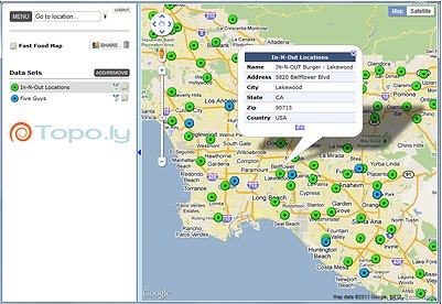
Topo.ly is a powerful tool allowing you to create a variety of google maps. I'm looking forward to trying it with toxic facilities. Use your imagination. Almost any point data in a spreadsheet should be made map ready with Topo.ly.
Learn more about Topo.ly
Mike Meuser
GIS Project Development, Data Research and Custom Shapefile Creation
Free GIS Software, Shapefiles, Maps and Tutorials
Free GPS, Aerial, TOPO Maps and News
If you have data, GIS project or custom shapefile needs send me an email
Premium Shapefiles: ZipCode, Indian & Federal Lands, School Districts, Tornadoes, Dams, Climate Change & Global Warming
Thursday, July 21, 2011
Discount U.S. Zip Code Shapefiles Based on 2010 U.S. Census Data. Why pay more?
I'm amazed at how much some companies charge for Zip Code boundary shapefiles. It makes no sense to me. Don't pay hundreds until you check these out.

Check out cheap Zip Code GIS shapefiles based on 2010 Census data here
Mike Meuser
GIS Project Development, Data Research and Custom Shapefile Creation
Free GIS Software, Shapefiles, Maps and Tutorials
Free GPS, Aerial, TOPO Maps and News
If you have data, GIS project or custom shapefile needs send me an email
Premium Shapefiles: ZipCode, Indian & Federal Lands, School Districts, Tornadoes, Dams, Climate Change & Global Warming
Tuesday, July 19, 2011
East Somerville Community Mapping Project
I'll be updating the Resources for Community Mapping and Public Participation GIS page with new resources and projects.
The first project is the East Somerville Community Mapping Project. I hope that it will inspire you. If you are involved in a project or know of one, let me know.
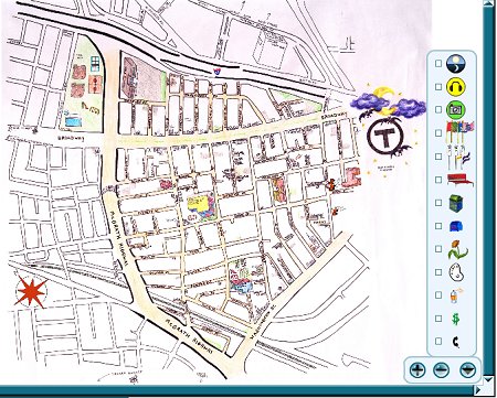
This is a community map of East Somerville, located just northwest of Boston. Where are the community gardens? Do the bus stops have benches or shelters? What intersections have more foot traffic at different times in the day? Take a look at East Somerville through the eyes and ears of people who live here.
Learn more about the East Somerville Community Mapping Project
Mike Meuser
GIS Project Development, Data Research and Custom Shapefile Creation
Free GIS Software, Shapefiles, Maps and Tutorials
Free GPS, Aerial, TOPO Maps and News
If you have data, GIS project or custom shapefile needs send me an email
Premium Shapefiles: ZipCode, Indian & Federal Lands, School Districts, Tornadoes, Dams, Climate Change & Global Warming
The first project is the East Somerville Community Mapping Project. I hope that it will inspire you. If you are involved in a project or know of one, let me know.
This is a community map of East Somerville, located just northwest of Boston. Where are the community gardens? Do the bus stops have benches or shelters? What intersections have more foot traffic at different times in the day? Take a look at East Somerville through the eyes and ears of people who live here.
Learn more about the East Somerville Community Mapping Project
Mike Meuser
GIS Project Development, Data Research and Custom Shapefile Creation
Free GIS Software, Shapefiles, Maps and Tutorials
Free GPS, Aerial, TOPO Maps and News
If you have data, GIS project or custom shapefile needs send me an email
Premium Shapefiles: ZipCode, Indian & Federal Lands, School Districts, Tornadoes, Dams, Climate Change & Global Warming
Monday, July 18, 2011
Community Mapping & Public Participation GIS Resources
I've recently updated our Resources for Community Mapping and Public Participation GIS page. I welcome any additions that you might have. Also, if you have done or are in the midst of doing or know of any projects, I'd love to list them on Maptivist.com.
Check out the resources for community mapping and public participation GIS here
Mike Meuser
GIS Project Development, Data Research and Custom Shapefile Creation
Free GIS Software, Shapefiles, Maps and Tutorials
Free GPS, Aerial, TOPO Maps and News
If you have data, GIS project or custom shapefile needs send me an email
Premium Shapefiles: ZipCode, Indian & Federal Lands, School Districts, Tornadoes, Dams, Climate Change & Global Warming
Thursday, July 14, 2011
ALEC (American Legislative Exchange Council) Exposed - 800+ Pieces of State & Federal Legislation Meant to Boost Corporate Profits at Our Expense
It is no longer conservative vs. liberal, republican vs. democrat. It's the rich vs. the rest of us. Give me a break - undermining social security is good for us? Getting rid of the minimum wage is good for us? Privatizing everything is good for us? Undoing pollution rules is good for us? We are being pounded with "get government out of the way" when we should be saying, "let's take back the government from the rich and make it work!"
More tax breaks for the rich?? Come on - enough! We need to tax the rich more and then SPEND the money here in the U.S. rebuilding our infrastructure, greening our energy, providing healthcare, building up our public education... That's how to put people back to work in good jobs that pay a LIVING WAGE. Once and for all let's get it right! Trickle-down does NOT work - never has, never will.
Take a look at this CommonDreams article, ALEC Exposed: A Nationwide Blueprint for the Rightwing Takeover. Here's an excerpt
Go to the ALEC Exposed Website.
Take a look at the legislators, funders, corporations... If any of this gives you any ideas about how maps might tell a story, drop me a note from any page on MapCruzin.com. Maybe we can put something together!
Mike Meuser
GIS Project Development, Data Research and Custom Shapefile Creation
Free GIS Software, Shapefiles, Maps and Tutorials
Free GPS, Aerial, TOPO Maps and News
If you have data, GIS project or custom shapefile needs send me an email
Premium Shapefiles: ZipCode, Indian & Federal Lands, School Districts, Tornadoes, Dams, Climate Change & Global Warming
More tax breaks for the rich?? Come on - enough! We need to tax the rich more and then SPEND the money here in the U.S. rebuilding our infrastructure, greening our energy, providing healthcare, building up our public education... That's how to put people back to work in good jobs that pay a LIVING WAGE. Once and for all let's get it right! Trickle-down does NOT work - never has, never will.
Take a look at this CommonDreams article, ALEC Exposed: A Nationwide Blueprint for the Rightwing Takeover. Here's an excerpt
“Never has the time been so right,” Louisiana State Representative Noble Ellington told conservative legislators gathered in Washington to plan the radical remaking of policies in the states. It was one month after the 2010 midterm elections. Republicans had grabbed 680 legislative seats and secured a power trifecta—control of both legislative chambers and the governorship—in twenty-one states. Ellington was speaking for hundreds of attendees at a “States and Nation Policy Summit,” featuring GOP stars like Texas Governor Rick Perry, former House Speaker Newt Gingrich and House Majority Leader Eric Cantor. Convened by the American Legislative Exchange Council (ALEC)—“the nation’s largest, non-partisan, individual public-private membership association of state legislators,” as the spin-savvy group describes itself—the meeting did not intend to draw up an agenda for the upcoming legislative session. That had already been done by ALEC’s elite task forces of lawmakers and corporate representatives. The new legislators were there to grab their weapons: carefully crafted model bills seeking to impose a one-size-fits-all agenda on the states.
Go to the ALEC Exposed Website.
Take a look at the legislators, funders, corporations... If any of this gives you any ideas about how maps might tell a story, drop me a note from any page on MapCruzin.com. Maybe we can put something together!
Mike Meuser
GIS Project Development, Data Research and Custom Shapefile Creation
Free GIS Software, Shapefiles, Maps and Tutorials
Free GPS, Aerial, TOPO Maps and News
If you have data, GIS project or custom shapefile needs send me an email
Premium Shapefiles: ZipCode, Indian & Federal Lands, School Districts, Tornadoes, Dams, Climate Change & Global Warming
Sunday, July 10, 2011
GIS for Home Schoolers, Students, Job Changers
GIS is a wonderful way to visualize trends and connections in data that might otherwise not be so obvious or might be missed altogether. GIS can be learned by young and old, school students and home-schoolers. For those already in a career, GIS can add extra value to your position. If you are new to GIS, I've prepared a brief introduction.
Next, consider learning the basics of GIS with the free Learn2Map GIS Tutorial and Shapefile Atlas. It includes free GIS software and access to free GIS shapefiles.
Once you have completed the tutorial, you can find free GIS software applications and free GIS shapefiles at MapCruzin.com.
You can check out some of the things we have done with GIS at Maptivist.com.
Mike Meuser
GIS Project Development, Data Research and Custom Shapefile Creation
Free GIS Software, Shapefiles, Maps and Tutorials
Free GPS, Aerial, TOPO Maps and News
If you have data, GIS project or custom shapefile needs send me an email
Premium Shapefiles: ZipCode, Indian & Federal Lands, School Districts, Tornadoes, Dams, Climate Change & Global Warming
Thursday, July 7, 2011
Maps + Activism = Maptivism
We are putting together a new website called Maptivist.com. It is basically a chronicle of our efforts towards maptivism (maps + activism).
In it I point to some of the projects we have done since the early 1990s beginning with our Santa Cruz Toxic Release Inventory - the first U.S. based interactive toxic maps on the internet.
I have two hopes for this. First, I'm hoping that our work will inspire you. Secondly, I'd like to highlight your maptivist projects. So if you are working on a project, know of one or plan one, let me know. I'd love to describe it and link to it from Maptivist.com.
Visit Maptivist.com
Mike Meuser
GIS Project Development, Data Research and Custom Shapefile Creation
Free GIS Software, Shapefiles, Maps and Tutorials
Free GPS, Aerial, TOPO Maps and News
If you have data, GIS project or custom shapefile needs send me an email
Premium Shapefiles: ZipCode, Indian & Federal Lands, School Districts, Tornadoes, Dams, Climate Change & Global Warming
Monday, July 4, 2011
Interactive Web Maps of the Impacts of Sea Level Rise in the U.S. and the World
The Department of Geoscience, Environmental Studies Laboratory at the University of Arizona has created two web map applications. One for the U.S. and the other for the World - both help assess and anticipate the impacts of global warming induced sea level rise.


Access the Impacts of Sea Level Rise Maps Now
Mike Meuser
GIS Project Development, Data Research and Custom Shapefile Creation
Free GIS Software, Shapefiles, Maps and Tutorials
Free GPS, Aerial, TOPO Maps and News
If you have data, GIS project or custom shapefile needs send me an email
Premium Shapefiles: ZipCode, Indian & Federal Lands, School Districts, Tornadoes, Dams, Climate Change & Global Warming
Friday, July 1, 2011
Interactive Climate Hot Maps
Explore the effects of global warming and climate change around the globe.
Explore Global Warming Hot Spots Now
Mike Meuser
GIS Project Development, Data Research and Custom Shapefile Creation
Free GIS Software, Shapefiles, Maps and Tutorials
Free GPS, Aerial, TOPO Maps and News
If you have data, GIS project or custom shapefile needs send me an email
Premium Shapefiles: ZipCode, Indian & Federal Lands, School Districts, Tornadoes, Dams, Climate Change & Global Warming
Wednesday, June 15, 2011
Extreme Weather, Natural Disaster, Weather Warning, Climate Change Maps, GIS Shapefiles & Resources
Scientists say solar activity is decreasing. Does this mean a new ice age is coming?
The weather this winter and spring has been quite dramatic around the globe. I've gathered some resources that you can use to help prepare yourself for and understand these extreme climate events. Some of these include space weather, climate change impact assessments, natural disaster shapefiles, extreme weather maps, NOAA national warning maps...
Click here to access extreme weather maps, shapefiles and resources.
Mike Meuser
GIS Project Development, Data Research and Custom Shapefile Creation
Free GIS Software, Shapefiles, Maps and Tutorials
Free GPS, Aerial, TOPO Maps and News
If you have data, GIS project or custom shapefile needs send me an email
Premium Shapefiles: ZipCode, Indian & Federal Lands, School Districts, Tornadoes, Dams, Climate Change & Global Warming
Tuesday, June 14, 2011
Free International ArcGIS Shapefiles & Adobe Illustrator Maps Updated - Download Now
Cloudmade has recently updated their international shapefiles. These are derived from the Openstreetmap project. Each country set contains seperate shapefiles for the following:
- highways (roads, footpaths)
- natural, (park and forest area polygons
- points of interest (amenity and tourist attraction points)
- administrative boundaries
- coastlines
- water bodies.
- OSM XML extracts by country
- Garmin Map Files (OSM.err edition)
- Osmosis country bounding polygon
- Navit maps by country
- GPX POI by country
- TomTom POI by country
- OSM XML feature extracts by country
- Adobe Illustrator format country maps
Monday, June 13, 2011
Maps for Wildfire Season
All the precipitation in the West means increased fuel for wildfires. We've collected quite a few resources that should be of interest. Here's an example maps:

Check here for more wildfire related mapping and GIS resources
Mike Meuser
GIS Project Development, Data Research and Custom Shapefile Creation
Free GIS Software, Shapefiles, Maps and Tutorials
Free GPS, Aerial, TOPO Maps and News
If you have data, GIS project or custom shapefile needs send me an email
Premium Shapefiles: ZipCode, Indian & Federal Lands, School Districts, Tornadoes, Dams, Climate Change & Global Warming
Tuesday, June 7, 2011
Getting a Handle on Climate Change and What it Means for OUR FUTURE
It's been an amazing year. Tornadoes, floods, cold snaps, record rain and snowfall. I live in California and last week 4 tornadoes touched down in the Sacramento Valley and one twisted around for an hour flinging almond trees all over the place. We don't see many tornadoes in California. Winter is still here. We actually had a few days of spring last month, but been below freezing at 4,000 feet every night where I live in the Sierra Nevada Mountains.
And, of course, to add insult to injury so to speak, the record precipitation is bringing all the radioactivity from the 3 Fukushima meltdowns right down to the ground where we all live - why isn't this in the news everyday? Well, that's another story.
OH, and by the way, the world is also creating more CO2 than ever before - another record!

It's time to get a handle on climate change and what it may mean for our future. The damage has been done and we've got to be as ready as we can. I've created some GIS shapefiles based on the most recent IPCC data. I used the A2 scenario because it seems to be the most likely to me. You can find out more about the IPCC scenarios here. With these shapefiles I can look at and compare various changes and scenarios for each decade from 2010 through 2099. I can:
And, of course, to add insult to injury so to speak, the record precipitation is bringing all the radioactivity from the 3 Fukushima meltdowns right down to the ground where we all live - why isn't this in the news everyday? Well, that's another story.
OH, and by the way, the world is also creating more CO2 than ever before - another record!
It's time to get a handle on climate change and what it may mean for our future. The damage has been done and we've got to be as ready as we can. I've created some GIS shapefiles based on the most recent IPCC data. I used the A2 scenario because it seems to be the most likely to me. You can find out more about the IPCC scenarios here. With these shapefiles I can look at and compare various changes and scenarios for each decade from 2010 through 2099. I can:
- Compare temperature changes throughout the year, month by month.
- Compare precipitation changes throughout the year, month by month.
- Combine the above and see where and when it's likely to snow or rain.
- Look at temperature changes and determine when a heavy snowpack might thaw quickly and early resulting in flooding.
- Look at temperature changes and detemine what might be the best vegetables to grow.
- Examine temperature changes and see what affect that might have on my land - wildlife and plantlife changes over time.
Thursday, June 2, 2011
U.S. Zip Code Shapefiles Based on 2010 Census
Download the latest U.S. Zip Code Shapefiles based on 2010 Census. Access the Zip Code shapefiles now.
Mike Meuser
GIS Project Development, Data Research and Custom Shapefile Creation
Free GIS Software, Shapefiles, Maps and Tutorials
Free GPS, Aerial, TOPO Maps and News
If you have data, GIS project or custom shapefile needs send me an email
Premium Shapefiles: ZipCode, Indian & Federal Lands, School Districts, Tornadoes, Dams, Climate Change & Global Warming
Sunday, May 29, 2011
U.S. Elementary, Secondary and Unified School District Shapefile Download
Now available for download are U.S. (50 states plus Puerto Rico) elementary, secondary and unified school district GIS shapefiles. Theses are the most current, based on the U.S. 2010 Census.
 Download the school district shapefiles
Mike Meuser
GIS Project Development, Data Research and Custom Shapefile Creation
Free GIS Software, Shapefiles, Maps and Tutorials
Free GPS, Aerial, TOPO Maps and News
If you have data, GIS project or custom shapefile needs send me an email
Premium Shapefiles: ZipCode, Indian & Federal Lands, School Districts, Tornadoes, Dams, Climate Change & Global Warming
Download the school district shapefilesMike Meuser
GIS Project Development, Data Research and Custom Shapefile Creation
Free GIS Software, Shapefiles, Maps and Tutorials
Free GPS, Aerial, TOPO Maps and News
If you have data, GIS project or custom shapefile needs send me an email
Premium Shapefiles: ZipCode, Indian & Federal Lands, School Districts, Tornadoes, Dams, Climate Change & Global Warming
Wednesday, May 25, 2011
U.S. Dams - Name, Location, Risk-Level, Purpose and Type of Dam Download ArcGIS Shapefiles
The Major Dams of the United States map layer is a subset of the 2005 National Inventory of Dams, extracted by the National Atlas of the United States®. It lists and describes more than 8,100 major dams in the United States, Puerto Rico, and the U.S. Virgin Islands. Major dams include dams 50 feet or more in height, dams with a normal storage capacity of 5,000 acre-feet or more, and dams with a maximum storage capacity of 25,000 acre-feet or more. Descriptive information includes the dam name and location, the risk level associated with the dam, the purposes for which the dam was constructed, and the dam type.
Download the U.S. Dams and Associated Risk Level Shapefiles
Mike Meuser
GIS Project Development, Data Research and Custom Shapefile Creation
Free GIS Software, Shapefiles, Maps and Tutorials
Free GPS, Aerial, TOPO Maps and News
If you have data, GIS project or custom shapefile needs send me an email
Premium Shapefiles: ZipCode, Indian & Federal Lands, School Districts, Tornadoes, Dams, Climate Change & Global Warming
Download Tornado GIS Shapefiles
U.S. Tornadoes from 1950 through 2008. The United States Tornado Touchdown Points 1950-2008 map layer includes tornado touchdown points for tornadoes that occurred in the United States, Puerto Rico, and the U.S. Virgin Islands. Descriptive information includes the latitude and longitude of the touchdown and lift-off points, the number of fatalities or injuries, an estimate of damage costs, and the classification of the storm on the Fujita Tornado Damage Scale.
Download U.S. Tornado GIS Shapefile Map Layers
Mike Meuser
GIS Project Development, Data Research and Custom Shapefile Creation
Free GIS Software, Shapefiles, Maps and Tutorials
Free GPS, Aerial, TOPO Maps and News
If you have data, GIS project or custom shapefile needs send me an email
Premium Shapefiles: ZipCode, Indian & Federal Lands, School Districts, Tornadoes, Dams, Climate Change & Global Warming
Sunday, May 15, 2011
What GIS Shapefiles Are You Looking For?
Hi - I'd like to hear from you. I try to create maps and shapefiles that are useful and of interest, but most of the time it's all about my own interest so I thought I'd ask all of you to let me know about the shapefiles that you need, are looking for, can't find, wish you had...
Please post here or email me at mike@mapcruzin.com
Once I've compiled your want-lists, I'll get to work on them. Thanks so much.
Mike Meuser
GIS Project Development, Data Research and Custom Shapefile Creation
Free GIS Software, Shapefiles, Maps and Tutorials
Free GPS, Aerial, TOPO Maps and News
If you have data, GIS project or custom shapefile needs send me an email
Premium Shapefiles: ZipCode, Indian & Federal Lands, School Districts, Tornadoes, Dams, Climate Change & Global Warming
Monday, May 9, 2011
IPCC: Renewable Energy Can Power the World
For years I've been asking myself why do we as a people (as in the government is us) invest major amounts in non-renewable, polluting, climate changing energy technologies while leaving table scraps for research and implementation of renewables? The answer, of course, is that unfortunately our government is not OUR government, not a government of the people, but a government of the rich and powerful who reap the benefits of government welfare and free research. Hopefully this report will begin to change the tide towards renewables and away from nuclear, coal, fracting, tar sands, oil shale... and any other unsustainable non-renewable energy source.
According to the IPCC, Close to 80 percent of the world’s energy supply could be met by renewables (solar, geothermal, ocean technologies, wind...) by mid-century if backed by the right enabling public policies a new report shows.
The findings, from over 120 researchers working with the Intergovernmental Panel on Climate Change (IPCC), also indicate that the rising penetration of renewable energies could lead to cumulative greenhouse gas savings equivalent to 220 to 560 Gigatonnes of carbon dioxide (GtC02eq) between 2010 and 2050.
Press release, download summary report, energy maps and shapefiles
Mike Meuser
GIS Project Development, Data Research and Custom Shapefile Creation
Free GIS Software, Shapefiles, Maps and Tutorials
Free GPS, Aerial, TOPO Maps and News
If you have data, GIS project or custom shapefile needs send me an email
Premium Shapefiles: ZipCode, Indian & Federal Lands, School Districts, Tornadoes, Dams, Climate Change & Global Warming
Wednesday, April 27, 2011
Maps of Tornadoes, Nuclear Power, Fukushima Like G.E Facilities in U.S.
Free U.S. Nuclear Reactor Power Plant, Tornadoes from 1950 through 2008, G.E. BWR Mark I Like Fukushima and Those with Inadequate Spent Fuel Rod Cooling Power Backup. Maps showing nuclear reactors addressed by Beyond Nuclear's petition to the NRC.


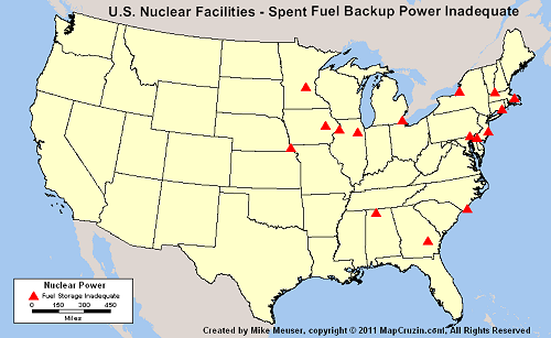
Learn more about the maps and download high resolution copies
Mike Meuser
GIS Project Development, Data Research and Custom Shapefile Creation
Free GIS Software, Shapefiles, Maps and Tutorials
Free GPS, Aerial, TOPO Maps and News
If you have data, GIS project or custom shapefile needs send me an email
Premium Shapefiles: ZipCode, Indian & Federal Lands, School Districts, Tornadoes, Dams, Climate Change & Global Warming
Monday, April 4, 2011
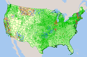
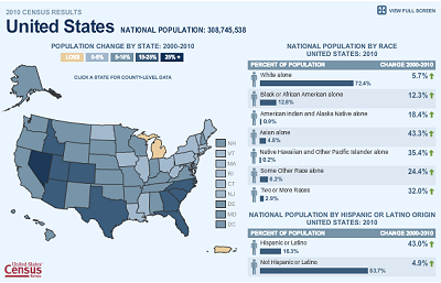
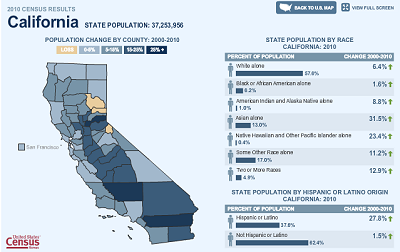
Census 2010 Interactive Population and Demographic Maps for Counties, States and Nation
The U.S. Census has completed the population and demographics portions of the 2010 census for redistricting congressional districts. This data is available in interactive maps at the county, state and national level.

Census 2010 Population Change. Click here for larger interactive maps.
Go To Interactive U.S. Census 2010 Interactive Population and Demographic Change Maps
Mike Meuser
GIS Project Development, Data Research and Custom Shapefile Creation
Free GIS Software, Shapefiles, Maps and Tutorials
Free GPS, Aerial, TOPO Maps and News
If you have data, GIS project or custom shapefile needs send me an email
Premium Shapefiles: ZipCode, Indian & Federal Lands, School Districts, Tornadoes, Dams, Climate Change & Global Warming
Census 2010 Population Change. Click here for larger interactive maps.
Census 2010 Demographic Change by State. Click here for larger interactive maps.
Census 2010 Population and Demographic Change State Maps.
Go To Interactive U.S. Census 2010 Interactive Population and Demographic Change Maps
Mike Meuser
GIS Project Development, Data Research and Custom Shapefile Creation
Free GIS Software, Shapefiles, Maps and Tutorials
Free GPS, Aerial, TOPO Maps and News
If you have data, GIS project or custom shapefile needs send me an email
Premium Shapefiles: ZipCode, Indian & Federal Lands, School Districts, Tornadoes, Dams, Climate Change & Global Warming
Saturday, April 2, 2011
GIS News Items: Live Training, Free Software, Redistricting
New items added to the MapCruzin.com GIS News, Views and Updates page.
Live Training: ArcGIS API for Windows Phone April 7, 2011 - ArcGIS for Windows Phone extends the reach of your GIS from the office to the mobile web. It includes a free downloadable app that adds basic mapping functionality to your Windows Phone device, as well as an API for developing custom applications.
Free 90 Day Trial of ESRI Community Analyst - Esri Community Analyst is a Web-based solution that provides GIS capabilities in a simple and easy-to-use framework. Thousands of demographic, health, economic, education, and business data variables, combined with instant reports and interactive color-coded maps, allow you to quickly explore the geographic characteristics of any area.
MapInfo Professional Free Trial Download - If you’re looking for a faster, easier way to create, share and use maps, try the world’s premier desktop mapping application for free!
Maptitude for Redistricting - The professional tool for political redistricting. It is used by a supermajority of the state legislatures, political parties, and public interest groups. Designed with the help of redistricting professionals, state legislatures, and political parties.
Maptitude for Redistricting is now available as an ArcGIS extension.
ESRI Redistricting is a Web-based solution for state and local governments, legislators, and advocacy groups to create political and geographic redistricting plans.
Access MapCruzin GIS News, Views and Updates page here.
Mike Meuser
GIS Project Development, Data Research and Custom Shapefile Creation
Free GIS Software, Shapefiles, Maps and Tutorials
Free GPS, Aerial, TOPO Maps and News
If you have data, GIS project or custom shapefile needs send me an email
Premium Shapefiles: ZipCode, Indian & Federal Lands, School Districts, Tornadoes, Dams, Climate Change & Global Warming
Wednesday, March 30, 2011
All Things Nuclear
Maps, GIS shapefiles, news, resources about nuclear energy, reactors, fallout dispersion, power, storage, meltdown, risks, fukushima, chernobyl, hazards, health, transportation and weapons.
View and Download All Things Nuclear
View and Download All Things Nuclear
Sunday, March 27, 2011
Heavy Flooding Coming to California and Nevada?
We've had a heavy snow year in the Sierra Nevada and Cascade mountains. Next week temperatures are forecast to increase dramatically in California and Nevada snow country. NOAA's California River Flood Center map shows that many California rivers are now above monitor stage and the Yolo Bypass is above flood stage and near the danger stage. We could be in for some major flooding.

Check NOAA's California and Nevada River Flood Center Maps
Mike
Free GIS Shapefiles, Maps, Tutorials and Software
Check NOAA's California and Nevada River Flood Center Maps
Mike
Free GIS Shapefiles, Maps, Tutorials and Software
Tuesday, March 22, 2011
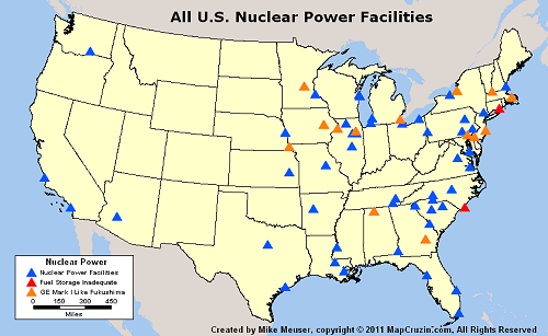
Updated Nuclear Facilities in the U.S. Maps, Shapefiles and Images - Download Free
Yesterday I asked the question, "How many nuclear reactors are there in the United States?" I asked this because after Greenpeace.org published my maps and download link on their blog, a person commented that there are 104 nuclear power plants in the U.S. not 63 as the blog said. At first I figured the confusion came about because some facilities have multiple reactors, but the numbers still didn't add up. As I looked into it further I was becoming increasingly dismayed because every data set I looked at was a bit different - facilities on one list didn't appear on others.
After examining lists in various reports and at government and NGO websites, I've determined that as of March 2011 there are 65 operating nuclear power facilities in the U.S. Each facility has from 1 to 3 reactors for a total of 104. This number does NOT account for those reactors that are decommissioned, reactors at research and university facilities or all of the nuclear waste at various locations around the United States. In time, I will make shapefiles available of these other nuclear hazards. See below for an updated nuclear and seismic hazards shapefile and spreadsheet that you may download and use as you wish.
Here's the new map based on this updated data:

For now, you can download an updated shapefile and speadsheet that shows all of these nuclear reactors that are currently operating in the U.S.
Also, I've added some map images in PNG, TIF and Acrobat PDF formats that you may download and use as you see fit.
Download the U.S. Nuclear Facility and Seismic Hazards Shapefiles, Maps and Images
After examining lists in various reports and at government and NGO websites, I've determined that as of March 2011 there are 65 operating nuclear power facilities in the U.S. Each facility has from 1 to 3 reactors for a total of 104. This number does NOT account for those reactors that are decommissioned, reactors at research and university facilities or all of the nuclear waste at various locations around the United States. In time, I will make shapefiles available of these other nuclear hazards. See below for an updated nuclear and seismic hazards shapefile and spreadsheet that you may download and use as you wish.
Here's the new map based on this updated data:
For now, you can download an updated shapefile and speadsheet that shows all of these nuclear reactors that are currently operating in the U.S.
Also, I've added some map images in PNG, TIF and Acrobat PDF formats that you may download and use as you see fit.
Download the U.S. Nuclear Facility and Seismic Hazards Shapefiles, Maps and Images
Monday, March 21, 2011
How many nuclear power plant reactors are there in the United States?
A few people visiting the nuclear power plant and seismic hazard page have noted that their only appears to be around 63 nuclear power plants on the map, yet, they say, there should be 104. At first I thought they were confused because many of the nuclear power plant facilities have more than one reactor. Some have as many as 3. So, I checked with the NRC and found 2 different lists that had 64 plants and 103 reactors, but the lists were not identical. A few plants appearing on one list, did not appear on the other. So, to get at the bottom of this and find the most current list of operating nuclear power plants in the U.S. I am going to compare the two NRC lists with those from Nukeworker.org, IEA and the World Nuclear Association and come up with THE list.
Note that if you look at the current spreadsheet or shapefile that you may download from this page, you will find several other types of nuclear related facilities besides Nuclear Power Plants. In the future, I'd like to also list and document all the non-energy related reactors that are in operation at national laboratories, universities, hospitals, research firms and elsewhere. Beyond that it is also important to document decommissioned nuclear power plants and other places that nuclear waste is currently stored.
View and download the nuclear power plant and seismic hazards shapefiles and spreadsheet
Thursday, March 17, 2011
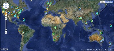
Maps of Nuclear Reactor Power Plants of the World
Navigate around the world or countries to find nuclear power plants. Click on a facility for more information.

Find nuclear reactor power plants around the world
Find nuclear reactor power plants around the world
Wednesday, March 16, 2011
Can a Fukushima Like Nuclear Accident Happen in the United States?
Yesterday I told you about free nuclear facility, seismic hazard and earthquake shapefiles. I've added a spreadsheet showing the names, locations and type of facilities that are included in the shapefile. These include Power Plant, Fuel Cycle Licensee, Material Licensee, Site Decommissioning, Uranium Mill Site, High Level Waste, and Independent Spent Fuel Storage Installation.
Download the nuclear facility spreadsheet and shapefiles here.
Download the nuclear facility spreadsheet and shapefiles here.
Tuesday, March 15, 2011
Free U.S. Seismic Hazard, Historical Earthquakes and Nuclear Reactor Power Plant ArcGIS Shapefiles
These ArcGIS shapefiles are derived from U.S. Government data sources. Layered together they show the proximity of nuclear reactors in the United States with historical earthquakes. They also show proximity to seismic hazard zones. Each shapefile set includes detailed source and data information in a metadata file.
I have provided some sample maps. I created these with Maptitude GIS. If you are new to GIS, check out our Learn2Map GIS Tutorial and Atlas, learn more and download a free GIS program that you can use to make your own maps with these shapefiles.

Nuclear Facilities and Seismic Hazard Zones

Nuclear Facilities and Historical U.S. Earthquakes

Nuclear Reactors in the United States

U.S. Seismic Hazard Zones
Download U.S. Nuclear Reactor, Historical Earthquakes and Seismic Hazard Shapefiles
I have provided some sample maps. I created these with Maptitude GIS. If you are new to GIS, check out our Learn2Map GIS Tutorial and Atlas, learn more and download a free GIS program that you can use to make your own maps with these shapefiles.
Nuclear Facilities and Seismic Hazard Zones
Nuclear Facilities and Historical U.S. Earthquakes
Nuclear Reactors in the United States
U.S. Seismic Hazard Zones
Download U.S. Nuclear Reactor, Historical Earthquakes and Seismic Hazard Shapefiles
Saturday, March 12, 2011
Japan Tsunami Maps and Shapefiles
We'll be adding more maps and shapefiles of Japan specifically related to the recent Tsunami and impending nuclear disaster. For now, here are a variety of maps of Japan. If you are looking for ArcGIS shapefiles of Japan, you can drill down to them beginning with "Asia" on this page.
Tuesday, March 8, 2011
TIGER/Line 2010 Census Redistricting (P.L. 94-171) ArcGIS Shapefile
The U.S. Census Bureau has made our job much easier. This is the fourth and latest release of the TIGER/Line files in ESRI ArcGIS shapefile format. Shapefiles work with most GIS programs including ArcGIS Explorer and ArcGIS. If you are new to GIS, take advantage of our Free GIS Tutorial and Atlas and learn the basics today. Click on a state or territory below to download its shapefiles and those for any county you select from the U.S. Census FTP site.
Download TIGER/Line Shapefiles
Visit MapCruzin.com for Free GIS Software Programs, Shapefiles, Maps, and Tutorials
Download TIGER/Line Shapefiles
Visit MapCruzin.com for Free GIS Software Programs, Shapefiles, Maps, and Tutorials
Thursday, March 3, 2011
2010 Census Redistricting [P.L. 94-171] Data and Shapefile Availability
Census 2010 Tiger/Line shapefiles are available for all 50 states, the District of Columbia, and Puerto Rico. Download from the U.S. Census Bureau's 2010 TIGER/Line products web page.
The technical documentation for the 2010 Census Redistricting [P.L. 94-171] TIGER/Line Shapefiles can be accessed here.
The following redistricting data files (2010 population and housing characteristics) are now available from the American Factfinder:
Alabama
Arkansas
Colorado
Delaware
Hawaii
Illinois
Indiana
Iowa
Kansas
Louisiana
Maryland
Mississippi
Missouri
Nebraska
Nevada
New_Jersey
North_Carolina
Oklahoma
Oregon
South_Dakota
Texas
Visit MapCruzin.com for Free GIS Software Programs, Shapefiles, Maps, and Tutorials
Take a Ride with Trimble Mobile Mapping
Taking a Ride with Trimble Mobile Mapping
Trimble Mobile Mapping
Trimble Mobile Mapping
Visit MapCruzin.com for Free GIS Software Programs, Shapefiles, Maps, and Tutorials
Nevada Geographic Information Society Annual Conference, Reno, Nevada
Here's a headsup to all of you in Nevada or Northern California. The Nevada Geographic Information Society is holding their annual conference in Reno at the Atlantis Casino, May 9 – 11, 2011.
The 2011 Annual Conference theme is "GIS At Your Service". This is a particularly apt theme, as geographic information systems have expanded in to every facet of public life. From routine commerce to personal navigation, to emergency services, geographic information systems have become an integral part of the fabric of our society. Once the province of a few experts, geographic data systems are now so ubiquitous that it is taken for granted. The 2011 conference will showcase many of the services that GIS provides and give us all a glimpse of many such services that lie just over the horizon. See the link on this page to get more conference information, to register, and to submit papers and session plans.
More information and to register for the NGIS 2011 Conference
Visit MapCruzin.com for Free GIS Software Programs, Shapefiles, Maps, and Tutorials
Friday, February 25, 2011
Extreme Weather, Natural Disaster, Weather Warning, Climate Change Maps and GIS Shapefiles
The weather this winter has been quite dramatic around the globe. Here are some resources that you can use to help prepare yourself for and understand these extreme climate events. You may View and download these extreme weather maps, resources and GIS shapefiles from MapCruzin.com
The Northeast Climate Impacts Assessment
Natural Disaster ArcGIS Shapefile Map Layer Series
Extreme Weather & Disaster Maps, Resources and GIS Shapefiles
Climate Change Impacts in the United States Maps, Charts, Tables
Interagency Climate Report, White House Releases Landmark Climate Change Report
Global Warming & Climate Change with Google Earth and Google Maps Mashups
NOAA National Weather Service National Warning GIS Maps
Temperature and Precipitation Forecasts 2010 through 2099 Based on IPCC Data
NOAA National Weather Hazards Map
Visit MapCruzin.com for Free GIS Software Programs, Shapefiles, Maps, and Tutorials
Wednesday, February 23, 2011
Free Maps Countries Experiencing Unrest, Protest, Revolution
Here are some free maps of countries experiencing unrest, protest and revolt over the last few months. They are in high resolution image of PDF formats and are free to download and use. You may view and download these at MapCruzin.com
Specific Countries:
Algeria
Bahrain
China
Egypt
Saudia Arabia
Libya
Syria
Tunisia
Yemen
Zimbabwe
Middle East Regional Maps:
Middle East (CIA Factbook)
Middle East Country Atlas Maps
Middle East Regional Maps
Related Maps:
Historical Maps of Africa
All World Country and Regional Maps
You may view and download these at MapCruzin.com
Visit MapCruzin.com for Free GIS Software Programs, Shapefiles, Maps, and Tutorials
Friday, January 28, 2011
Financial Crisis Inquiry Report Downloads Now Available
We're all impacted by recent economic events and the recession that we're now in. January 27, 2011 the FCIC released the Financial Crisis Inquiry Report to the public. I have made it available in Acrobat PDF format for you to download. In the ensuing days and weeks I will be adding many more reports, hearings, testimonies, videos, maps, regional impacts and related materials.
Download the Financial Crisis Inquiry Report
Download the Financial Crisis Inquiry Report
Subscribe to:
Posts (Atom)

