
Download the latest U.S. Zip Code Shapefiles based on 2010 Census. Access the Zip Code shapefiles now.
Mike Meuser
GIS Project Development, Data Research and Custom Shapefile Creation
Free GIS Software, Shapefiles, Maps and Tutorials
Free GPS, Aerial, TOPO Maps and News
If you have data, GIS project or custom shapefile needs send me an email
Premium Shapefiles: ZipCode, Indian & Federal Lands, School Districts, Tornadoes, Dams, Climate Change & Global Warming
Thursday, June 2, 2011
Sunday, May 29, 2011
U.S. Elementary, Secondary and Unified School District Shapefile Download
Now available for download are U.S. (50 states plus Puerto Rico) elementary, secondary and unified school district GIS shapefiles. Theses are the most current, based on the U.S. 2010 Census.
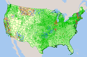 Download the school district shapefiles
Mike Meuser
GIS Project Development, Data Research and Custom Shapefile Creation
Free GIS Software, Shapefiles, Maps and Tutorials
Free GPS, Aerial, TOPO Maps and News
If you have data, GIS project or custom shapefile needs send me an email
Premium Shapefiles: ZipCode, Indian & Federal Lands, School Districts, Tornadoes, Dams, Climate Change & Global Warming
Download the school district shapefilesMike Meuser
GIS Project Development, Data Research and Custom Shapefile Creation
Free GIS Software, Shapefiles, Maps and Tutorials
Free GPS, Aerial, TOPO Maps and News
If you have data, GIS project or custom shapefile needs send me an email
Premium Shapefiles: ZipCode, Indian & Federal Lands, School Districts, Tornadoes, Dams, Climate Change & Global Warming
Subscribe to:
Comments (Atom)

