Saturday, January 23, 2010

MapCruzin Free GIS Software, Geospatial Data, Shapefiles, GPS, Topo, Satellite, Maps and Tutorials

We've been online since 1996. We provide free and open source GIS software applications, maps, geospatial data and shapefiles, tutorials and resources for students, cartographers, geographers, GIS professionals, neogeographers and neocartographers.

We also provide free satellite and aerial photography imagery and maps, Google Earth & Maps mashups, resources and tools; topographic maps, and GPS applications, data and software. Some of the main categories and recent additions are listed below. Specific items are listed in the right column of each page.

We post new additions on the MapCruzin Blog. You may want to subscribe to our feeds and occasional newsletters by entering your email address in the box at the top of the left column. You can also subscribe to our RSS feed. You can also follow us on twitter.

Thank you so much for visiting. We depend on your input to help us make this a better resource. If you have suggestions, please feel free to contact me (see contact info at bottom of each page).


MapCruzin.com for free GIS, shapefiles, maps, GPS, Topo and tutorials.

Friday, January 22, 2010

Haiti Earthquake Free Maps and Related Resources

Growing list of free and open source maps, web maps and related information and geospatial data related to the 2010 earthquake in Haiti. If you have more to add please post them below. Thanks.

Access the Haiti Earthquake Free Maps and Related Resources


Wednesday, January 20, 2010

Income, Poverty and Health Insurance Coverage in the United States

The uninsured rate and number of uninsured for non-Hispanic Whites increased in 2008 to 10.8 percent and 21.3 million, from 10.4 percent and 20.5 million in 2007. The uninsured rate and number of uninsured for Blacks in 2008 were not statistically different from 2007, at 19.1 percent and 7.3 million.

The percentage of uninsured Hispanics decreased to 30.7 percent in 2008, from 32.1 percent in 2007. The number of uninsured Hispanics was not statistically different in 2008, at 14.6 million.

In 2008, the percentage and number of children under 18 without health insurance were 9.9 percent and 7.3 million, lower than they were in 2007 at 11.0 percent and 8.1 million. The uninsured rate and the number of uninsured for children are the lowest since 1987, the first year that comparable health insurance data were collected. Although the uninsured rate for children in poverty decreased to 15.7 percent in 2008, from 17.6 percent in 2007, children in poverty were more likely to be uninsured than all children.

View Income, Poverty and Health Insurance Coverage in the United States and Download Data, Tables and Figures

Tuesday, January 19, 2010

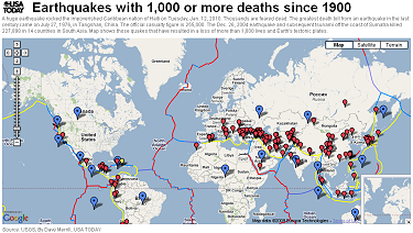
Earthquakes with 1,000 or more deaths since 1900 Mashup

A huge earthquake rocked the impoverished Caribbean nation of Haiti on Tuesday, Jan. 12, 2010. Thousands are feared dead. The greatest death toll from an earthquake in the last century came on July 27, 1976, in Tangshan, China. The official casualty figure is 255,000. The Dec. 26, 2004 earthquake and subsequent tsunami off the coast of Sumatra killed 227,898 in 14 countries in South Asia. Map shows those quakes that have resulted in a loss of more than 1,000 lives and Earth's tectonic plates.


Earthquake Mashup


ERDAS Releases a New Version of Titan, its Free 3D Visualization Client

ERDAS announces the release of ERDAS TITAN Client 2010, a free, downloadable 3D visualization client that includes the ERDAS TITAN Viewer and the Geospatial Instant Messenger (GeoIM). The ERDAS TITAN Viewer supports visualization of data and web services from a variety of enterprise applications and allows users to create sharable data and content mashups in a 3D globe. The GeoIM enables permission-based desktop data publishing and consumption.

The ERDAS TITAN Client seamlessly connects to ERDAS APOLLO. ERDAS APOLLO is a geospatial enterprise product equipped to fully understand, competently manage and rapidly serve large volumes of vector, raster and terrain data. ERDAS APOLLO implements an out-of-the box Service Oriented Architecture (SOA) that provides a publish, find and bind workflow for any data type.

In ERDAS TITAN Client 2010, users may connect to ERDAS APOLLO catalogs via the TITAN Viewer to execute geoprocesses and visualize results in a 3D virtual globe. Descriptive metadata search results from ERDAS APOLLO catalogs are now also available in an easy-to-read display pane. Search and discovery of data in an APOLLO catalog is much faster, due to integration of REST/JSON API.

Read more and download Erdas Titan