
3map is a Free Software
project being built with the support of the Telstra Broadband Fund that provides the client and server capabilities to deliver the Web Augmented Virtual Earth.
52°North Initiative for Geospatial Open Source Software GmbH is an international research and development company whose mission is to promote the conception, development and application of free open source geo-software for research, education, training and practical use.
AccuGlobe Desktop 2007 is free to download. Add specific functionality with extensions and plugins.
Aero-Triangulation System
software - A collection of Fortran and C programs, UNIX shell scripts, and text files used to perform image coordinate refinement, block adjustment, statistical reporting, and plotting.
AGIS for Windows A simple mapping and GIS shareware package that includes a tutorial to help you with making your own map displays.
ArcGIS Explorer and ArcExplorer are freely available, easy to use, geographic data viewers whose purpose is to allow organizations to provide access to their GIS to a wide audience of non-expert users.
ArcVoyager was created by ESRI's Schools and Libraries team to go along with ArcView. It is a 50-mb package of carefully selected data, ArcView projects, and help files, in a tiered format. There are comparable Windows and Macintosh versions.
Atlas aims to produce and display high quality charts of the world for users of FlightGear, an open source flight simulator.
AtlasStyler is a user-friendly application to style geodata. The resulting styles can be saved to XML files that follow the OGC SLD/SE standard 1.0.
AutoREALM is a Free GNU mapping software (a "cartographer") that can design maps of castles, cities, dungeons and more. AutoREALM is generally used by Role-playing Game practicants who enjoy doing their own maps. But it could fits the needs of other people.
AVPython - By embedding Python within ArcView GIS, we can break through most of the barriers to interoperability, scalability, and extensibility that the Avenue developer faces when trying to build a modern application. Unlike Avenue, Python is a real programming language suitable for large-scale collaborative development, yet like Avenue it is easy to use, and very easy to read.
Basins - Installation software that contains the BASINS Version 4.0 system, data download tool, full documentation in the pulldown help menu, and the tutorial project and data(HUC-02060006) is now available. BASINS 4.0 contains the installation program for an open source GIS program.
Batik is a Java-based toolkit for applications or applets that want to use images in the Scalable Vector Graphics (SVG) format for various purposes, such as display, generation or manipulation.
BBBike is a route-finder for
cyclists in Berlin and Brandenburg (Germany). BBBike can be run as a stand-alone program (using tk) or as a simpler web based component.
BuddySpace is an instant messenger with four novel twists: (1) it allows optional maps for geographical & office-plan visualizations in addition to standard 'buddy lists' ...
Cameo, Marplot and Aloha - free software and data used to map the dispersion of toxic chemicals and help respond to chemical emergencies.
Cartographic Objects for Zope 0.7 features enhanced labeling of features, catalog-like search for features from data stores, and improved management interface for data stores.
CartoWeb is a comprehensive and ready-to-use Web-GIS (Geographical Information System) as well as a convenient framework for building advanced and customized applications.
Download Free GIS Software Programs from Mapcruzin.com
Saturday, May 8, 2010
Wednesday, May 5, 2010
SkyTruth Remote Sensing Image Maps of Gulf Oil Spill
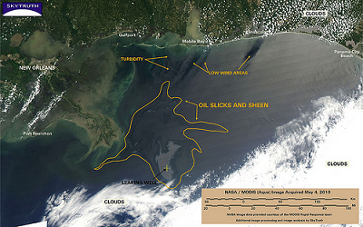
SkyTruth uses remote sensing and digital mapping to educate the public and policymakers about the environmental consequences of human activities, and to hold corporations and governments to higher standards of accountability around the globe.

SkyTruth is monitoring the growing oil spill in the Gulf of Mexico using NASA/MODIS satellite imagery and publishing daily reports and analysis as the situation develops.
Learn More and View All of SkyTruth's Map Images
Free GIS Software Program Application Downloads & Resources Page 2 of 9
Community MapBuilder - MapBuilder is a powerful, standards compliant, open source geographic mapping client which runs in a web browser. Using MapBuilder, Web designers can concentrate on the presentation and usability using HTML with simple links to the MapBuilder JavaScript code.
CPSGeo - Simple GIS for CPS - Cartographic maps are extremely useful tools for analyzing and summarizing information with a spatial component, and many CPS documents have a spatial component: events happen at places, and reports are often concerned with places.
CRAN Task View: Analysis of Spatial Data - For spatial analysis, disease and ecological mapping and more.
CrimeStat III is Windows-based and interfaces with most desktop GIS programs. The purpose is to provide supplemental statistical tools to aid law enforcement agencies and
criminal justice researchers in their crime mapping efforts.
CycleAtlas is a free, open-source software for managing track rides, mainly intented for cycling and other open air sports.
DC Maintenance Management System - A web-based maintenance management system for water and wastewater networks. Allows to store customer complaints and issue workorder sheets.Rather than using street names, maps and landmarks are used for navigation.
deegree - Free Software for Spatial Data Infrastructures - offers the substantial building blocks for the building of a Spatial Data Infrastructure by implementing the standards of the Open Geospatial Consortium. Deegree components can be used to either develop a standalone desktop mapping solution to be locally installed on a users machine, or to set up a highly distributed and service-based infrastructure.
DIVA-GIS is a free computer program for mapping and geographic data analysis (a geographic information system (GIS). With DIVA-GIS you can make maps of the world, or of a very small area, using, for example, state boundaries, rivers, a satellite image, and the locations of sites where an animal species was observed. We also provide free spatial data for the whole world that you can use in DIVA-GIS or other programs.
dlgv32 Pro is a limited-feature version of commercial software called Global Mapper which was created from the original dlgv32 source code. Improved to address changes in data standards and to better meet customer requirements, dlgv32 Pro continues the tradition of providing quality viewing software for USGS data users.
DraconesPH is a public health surveillance application. It is an example of a complete application that can be built using the Dracones framework components. The development of the initial version was funded in part by GeoConnections, and is currently running at the Direction de sante publique de Montreal (Montreal Public Health), where it serves as an add-on for the visual exploration and analysis of their massive, non-spatially enabled datasets.
edbs2wkt - converting the GIS-Format EDBS to Spatial-Database PostGIS and other using the Well Known Text-Interface. EDBS is a German Fileformat from ALK (Automatisierte Liegenschaftskarte).
Downnload this free GIS software from Mapcruzin.com
New to GIS? Check here to learn more. Mapcruzin.com also provides:
- a Free Learn2Map GIS Tutorial and Atlas
- Free ArcGIS shapefiles
- Free maps of the world
- free Google Earth and Google Maps mashups, software and tools
- Free Remote Sensing, Satellite Imagery, Aerial Photos, Maps, Tools and Software
- GPS Maps and Software Programs for Tracking and Navigation
- Free 7.5 Minute, 250K Topographic TOPO and Terrain Maps
Tuesday, May 4, 2010
Offshore Oil Spill Maps, Software and GIS Shapefiles
We are listing here a growing number of mapping and GIS resources related to offshore oil spills. Return soon for more maps, software and GIS shapefiles.

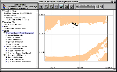
GNOME (General NOAA Operational Modeling Environment) is the oil spill trajectory model used by OR&R Emergency Response Division (ERD) responders during an oil spill.
ESI - Deepwater Horizon Gulf Oil Spill Environmental Sensitivity Index (ESI) Atlases - ESI Viewers are free tools that you can use to view and query Environmental Sensitivity Index (ESI) atlases using the MARPLOT mapping program and a FileMaker application.
GNOME (General NOAA Operational Modeling Environment) is the oil spill trajectory model used by OR&R Emergency Response Division (ERD) responders during an oil spill.
Subscribe to:
Comments (Atom)

