
The paths of tropical cyclones and major hurricanes from 1851 to 2004.
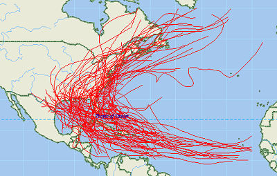
The term "tropical cyclone" is a generic term for a low-pressure storm system that usually forms in the tropics. The unpredictable behavior, high seas, and devastating winds of tropical storms have challenged us for centuries. One of our best defenses against hurricanes and other tropical storms is informed readiness. The National Hurricane Center (NHC), part of the National Oceanic and Atmospheric Administration, National Weather Service (NWS), collects tropical cyclone data as part of its mission to save lives and mitigate property loss by issuing advisories of hazardous tropical weather. The NHC tracks hurricanes and other tropical cyclones over the Atlantic, Caribbean, Gulf of Mexico, and Eastern Pacific and issues hurricane forecasts, watches, and warnings to the public. Computer models are used to forecast the track and intensity of a tropical storm. These statistical models use current information about a storm and compare it with historical knowledge about the behavior of similar tropical storms. The historical record for storms over the North Atlantic begins in 1851, and the record in the Pacific begins in 1949.
Download the free hurricane GIS shapefile map layers here
Mike Meuser
GIS Project Development, Data Research and Custom Shapefile Creation
Free GIS Software, Shapefiles, Maps and Tutorials
Free GPS, Aerial, TOPO Maps and News
If you have data, GIS project or custom shapefile needs send me an email
Premium Shapefiles: ZipCode, Indian & Federal Lands, School Districts, Tornadoes, Dams, Climate Change & Global Warming

