
Saturday, March 20, 2010
Chemical Security 101: What You Don't Have Can't Leak, or Be Blown Up by Terrorists
Most of the nation's 101 most dangerous chemical facilities could become less attractive terrorist targets by converting to alternative chemicals or processes. Doing so would improve the safety and security of more than 80 million Americans living within range of a worst-case toxic gas release from one of these facilities, according to data compiled for this report. Millions more living near railroads and highways used for transporting hazardous chemicals would also be safer and more secure.
The Department of Homeland Security and numerous security experts have repeatedly warned that terrorists could use industrial chemicals as improvised weapons of mass destruction. Current chemical security efforts, however, are inadequate to protect workplaces and communities.
Learn more and download Chemical Security 101: What You Don't Have Can't Leak, or Be Blown Up by Terrorists
Interactive Map of the Nation's 101 Most Dangerous Chemical Facilities
This map shows the locations of the nation's 101 most dangerous chemical facilities, each of which threatens some 1 million or more people. The vast majority of these facilities could convert to safer, more secure chemicals or processes.
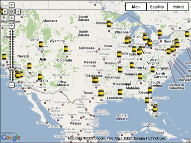
Most of the nation's 101 most dangerous chemical facilities could become less attractive terrorist targets by converting to alternative chemicals or processes. Doing so would improve the safety and security of the more than 80 million Americans who are living within range of a worst-case toxic gas release from one of these facilities, according to data compiled by Paul Orum and Reece Rushing in the report "Chemical Security 101: What You Don't Have Can't Leak, or Be Blown Up by Terrorists."
Use the interactive map and read the report
Friday, March 19, 2010
Free Learn to Map GIS Mapping Tutorial and Shapefile Atlas
Are you new to GIS (Geographic Information Systems) and mapping? Would you like to learn what it is all about and learn how to create your own maps? Would you like to begin a new professional career? Our free online Learn2Map GIS Mapping Tutorial and Atlas is designed to give you a quick-start introduction to the basics of GIS.
In just a few minutes you can begin to learn how to create digital maps. The easy-to-follow step-by-step distance learning online tutorial is based on free resources. There is nothing to purchase. All you need to begin mapping today is the free Learn2Map GIS Mapping Tutorial and Atlas.
I Hope that these prove useful to you. We have free GIS software available and there is plenty of free data and shapefiles that will work with these programs and the tutorial. More to come!
Click here for more about and access to the Learn2Map GIS Mapping Tutorial and Atlas
Mike
Thursday, March 18, 2010
Canada, Mexico, U.S. Transportation ArcGIS Shapefiles Free Download
Border Crossings
North American Higway Border Crossings 5.7K
North American Railroad Border Crossings 2.3K
Canadian Transportation Shapefiles
Canada Airports 42.1K
Canadian Highways 401K
Canada Ports 1.9K
Canada Provinces 2.5M
Canada Railroads 297K
Mexican Transportation Shapefiles
Mexico Airports 7.4K
Mexico Highways 156K
Mexico Ports 2.3K
Mexico States 534K
Mexico Railroads 64K
Mexico Highway Railroad Terminals 1.8K
United States Transportation Shapefiles
U.S. Airports 767K
U.S. Highways 30.5MB
U.S. Ports 9.1K
U.S. States 8.2MB
U.S. Auto Ramps 9.1K
U.S. Railroads 16.2MB
U.S. Intermodal 15.6K
I Hope that these prove useful to you. If you are new to GIS, check out the Learn2Map GIS Tutorial and Atlas. We have more free GIS software available and there is plenty of free data and shapefiles that will work with these programs. More to come!
Mike
National Transportation Atlas Database (NTAD) ArcGIS Shapefiles Free Download
NOTE: These data are provided in ESRI shapefile format. For your convenience and to improve your download performance, datasets that are larger than 20 mb are also available for download by smaller US DOT regions. There are 10 US DOT Regions, with each region being composed of 3 to 8 states. There are point, polyline and polygon shapefiles.
POINT ARCGIS SHAPEFILE LAYERS include Public-Use Airports, Alternative Fuels Stations, Amtrak Stations, Automatic Traffic Recorder Stations, Highway-Rail Grade Crossings, Intermodal Terminal Facilities, National Bridge Inventory, National Populated Places, U.S. Army Corps of Engineers Ports, and Weigh in Motion Stations ... Download the point shapefile map layers.
POLYLINE ARCGIS SHAPEFILE LAYERS include Freight Analysis Network, Hazardous Material Routes, Highway Performance Monitoring System, National Highway Planning Network, Railway Network, Fixed-Guideway Transit Facilities, and U.S. Army Corps of Engineers Navigable Waterway Network ... Download the polyline shapefile map layers.
POLYGONS ARCGIS SHAPEFILE LAYERS include Bureau of the Census Urbanized Area Boundaries, The 111th Congressional Districts Boundaries, U.S. County Boundaries, Hydrographic Features, U.S. Military Installations, Metropolitan Planning Organization, Core Based Statistical Areas, Non Attainment Areas (carbon monoxide, lead, nitrogen dioxide, ozone, particulate matter 10, particulate matter 2.5, sulfur oxides), and National Park System Boundary Dataset, U.S. State Boundaries ... Download the polygon shapefile map layers.
Wednesday, March 17, 2010
New Free GIS: FGS Linux, DraconesPH, SatScan, Fusion, ka-Map, MapFish
More new Free and Open Source GIS Software and Tools
The FGS Linux Installer is a self-extracting file that will install MapServer with PHP/MapScript and all of their dependencies on your Linux system. It provides a stand-alone environment with all the required software (incl. Apache and PHP) to run PHP/MapScript webmapping applications.
DraconesPH is a public health surveillance application. It is an example of a complete application that can be built using the Dracones framework components. The development of the initial version was funded in part by GeoConnections, and is currently running at the Direction de sante publique de Montreal (Montreal Public Health), where it serves as an add-on for the visual exploration and analysis of their massive, non-spatially enabled datasets.
SaTScan is a free software that analyzes spatial, temporal and space-time data using the spatial, temporal, or space-time scan statistics. It is designed for any of the following interrelated purposes ...
Fusion is a web-mapping application development framework for MapGuide OS and MapServer built primarily in JavaScript.
ka-Map ("ka" as in ka-boom!) is an open source project that is aimed at providing a javascript API for developing highly interactive web-mapping interfaces using features available in modern web browsers.
MapFish is a flexible and complete framework for building rich web-mapping applications. It emphasizes high productivity, and high-quality development.
I Hope that these prove useful to you. If you are new to GIS, check out the Learn2Map GIS Tutorial and Atlas. We have more free GIS software available and there is plenty of free data and shapefiles that will work with these programs. More to come!
Mike
Tuesday, March 16, 2010
New Listings Free GIS Software - Python, FWTools, PrimaGIS, Spatial Index
Most of these newly listed GIS software and tools are related to Python geographic programming.
Cartographic Objects for Zope 0.7 features enhanced labeling of features, catalog-like search for features from data stores, and improved management interface for data stores.
FWTools is a set of Open Source GIS binaries for Windows (win32) and Linux (x86 32bit) systems produced by me, Frank Warmerdam (ie. FW). The kits are intended to be easy for end users to install and get going with. No fudzing with building from source, or having to collect lots of interrelated packages.
OpenEV is a software library and application for viewing and analysing raster and vector geospatial data. OpenEV is used by private companies, universities, governments and non-profit organizations around the world.
PrimaGIS is a mapping solution meant primarily as a spatial extension for Archetypes based objects. The idea is to allow existing Archetypes based objects to be presented on predefined maps and allow users to easily access this spatial information in relation to the primary information of the objects. PrimaGIS is not a standalone application, but builds on top of Mapserver, Python Cartographic Library (PCL) and Cartographic Objects for Zope (ZCO).
Python is a remarkably powerful dynamic programming language that is used in a wide variety of application domains.
Python Cartographic Library (PCL) - Python is rapidly becoming the language of choice for GIS programming. At the fore of this movement have been AVPython, OpenEV, and Python bindings for GDAL and OGR. On their heels, ESRI now distributes Python with Arc 9 and other commercial vendors are following suit.
Spatial Index: This package provides a general framework for developing spatial indices. Currently it defines generic interfaces, provides simple main memory and disk based storage managers and a robust implementation of an R*-tree, an MVR-tree and a TPR-tree.
I Hope these prove useful to you. If you are new to GIS, check out the Learn2Map GIS Tutorial and Atlas. We have more free GIS software available and there is plenty of free data and shapefiles that will work with these programs. More to come!
Mike
Monday, March 15, 2010
New Free GIS Software - ILWIS, SharpMap, SAMT, Hidrosig, GeoVISTA, VGMap
New Free GIS Software Addtiions March 15, 2010
The Integrated Land and Water Information System (ILWIS) is a PC-based GIS & Remote Sensing software, developed by ITC up to release 3.3 in 2005. ILWIS comprises a complete package of image processing, spatial analysis and digital mapping.
SharpMap is a simple-to-use map renderer that renders GIS data for use in web and desktop applications. The engine is written in C# and based on the .NET 2.0 framework.
SAMT - Spatial Analysis and Modelling Tool - A modeling system with a few GIS-features, like spatial analysis, some spatial techniques and a simple in and export function to a GIS. The main focus is to have an open system to include different models.
HidroSIG - A Geographical Information System (GIS) with special tools that will allow you to make estimations and analysis of hydrological, climatic and geomorphological variables.
GeoVISTA Studio is an open software development environment designed for geospatial data. Studio is a programming-free environment that allows users to quickly build applications for geocomputation and geographic visualization.
VGMap is a new library created by Eyebeam R&D that allows designers, developers, and mapping geeks to overlay data on top of Google Maps in a richer way than is possible using their standard system. It is called VGMap because it adds vector-drawing capability to the already-awesome GMap API.
I Hope these prove useful to you. If you are new to GIS, check out the Learn2Map GIS Tutorial and Atlas. We have more free GIS software available and there is plenty of free data and shapefiles that will work with these programs. More to come!
Mike
Subscribe to:
Posts (Atom)

