SkyTruth uses remote sensing and digital mapping to educate the public and policymakers about the environmental consequences of human activities, and to hold corporations and governments to higher standards of accountability around the globe.

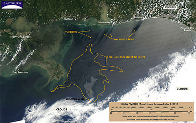
SkyTruth is monitoring the growing oil spill in the Gulf of Mexico using NASA/MODIS satellite imagery and publishing daily reports and analysis as the situation develops.
Learn More and View All of SkyTruth's Map Images


No comments:
Post a Comment