
3map is a Free Software
project being built with the support of the Telstra Broadband Fund that provides the client and server capabilities to deliver the Web Augmented Virtual Earth.
52°North Initiative for Geospatial Open Source Software GmbH is an international research and development company whose mission is to promote the conception, development and application of free open source geo-software for research, education, training and practical use.
AccuGlobe Desktop 2007 is free to download. Add specific functionality with extensions and plugins.
Aero-Triangulation System
software - A collection of Fortran and C programs, UNIX shell scripts, and text files used to perform image coordinate refinement, block adjustment, statistical reporting, and plotting.
AGIS for Windows A simple mapping and GIS shareware package that includes a tutorial to help you with making your own map displays.
ArcGIS Explorer and ArcExplorer are freely available, easy to use, geographic data viewers whose purpose is to allow organizations to provide access to their GIS to a wide audience of non-expert users.
ArcVoyager was created by ESRI's Schools and Libraries team to go along with ArcView. It is a 50-mb package of carefully selected data, ArcView projects, and help files, in a tiered format. There are comparable Windows and Macintosh versions.
Atlas aims to produce and display high quality charts of the world for users of FlightGear, an open source flight simulator.
AtlasStyler is a user-friendly application to style geodata. The resulting styles can be saved to XML files that follow the OGC SLD/SE standard 1.0.
AutoREALM is a Free GNU mapping software (a "cartographer") that can design maps of castles, cities, dungeons and more. AutoREALM is generally used by Role-playing Game practicants who enjoy doing their own maps. But it could fits the needs of other people.
AVPython - By embedding Python within ArcView GIS, we can break through most of the barriers to interoperability, scalability, and extensibility that the Avenue developer faces when trying to build a modern application. Unlike Avenue, Python is a real programming language suitable for large-scale collaborative development, yet like Avenue it is easy to use, and very easy to read.
Basins - Installation software that contains the BASINS Version 4.0 system, data download tool, full documentation in the pulldown help menu, and the tutorial project and data(HUC-02060006) is now available. BASINS 4.0 contains the installation program for an open source GIS program.
Batik is a Java-based toolkit for applications or applets that want to use images in the Scalable Vector Graphics (SVG) format for various purposes, such as display, generation or manipulation.
BBBike is a route-finder for
cyclists in Berlin and Brandenburg (Germany). BBBike can be run as a stand-alone program (using tk) or as a simpler web based component.
BuddySpace is an instant messenger with four novel twists: (1) it allows optional maps for geographical & office-plan visualizations in addition to standard 'buddy lists' ...
Cameo, Marplot and Aloha - free software and data used to map the dispersion of toxic chemicals and help respond to chemical emergencies.
Cartographic Objects for Zope 0.7 features enhanced labeling of features, catalog-like search for features from data stores, and improved management interface for data stores.
CartoWeb is a comprehensive and ready-to-use Web-GIS (Geographical Information System) as well as a convenient framework for building advanced and customized applications.
Download Free GIS Software Programs from Mapcruzin.com
Saturday, May 8, 2010


Wednesday, May 5, 2010
SkyTruth Remote Sensing Image Maps of Gulf Oil Spill
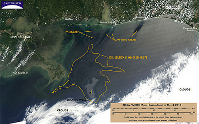
SkyTruth uses remote sensing and digital mapping to educate the public and policymakers about the environmental consequences of human activities, and to hold corporations and governments to higher standards of accountability around the globe.

SkyTruth is monitoring the growing oil spill in the Gulf of Mexico using NASA/MODIS satellite imagery and publishing daily reports and analysis as the situation develops.
Learn More and View All of SkyTruth's Map Images
Free GIS Software Program Application Downloads & Resources Page 2 of 9
Community MapBuilder - MapBuilder is a powerful, standards compliant, open source geographic mapping client which runs in a web browser. Using MapBuilder, Web designers can concentrate on the presentation and usability using HTML with simple links to the MapBuilder JavaScript code.
CPSGeo - Simple GIS for CPS - Cartographic maps are extremely useful tools for analyzing and summarizing information with a spatial component, and many CPS documents have a spatial component: events happen at places, and reports are often concerned with places.
CRAN Task View: Analysis of Spatial Data - For spatial analysis, disease and ecological mapping and more.
CrimeStat III is Windows-based and interfaces with most desktop GIS programs. The purpose is to provide supplemental statistical tools to aid law enforcement agencies and
criminal justice researchers in their crime mapping efforts.
CycleAtlas is a free, open-source software for managing track rides, mainly intented for cycling and other open air sports.
DC Maintenance Management System - A web-based maintenance management system for water and wastewater networks. Allows to store customer complaints and issue workorder sheets.Rather than using street names, maps and landmarks are used for navigation.
deegree - Free Software for Spatial Data Infrastructures - offers the substantial building blocks for the building of a Spatial Data Infrastructure by implementing the standards of the Open Geospatial Consortium. Deegree components can be used to either develop a standalone desktop mapping solution to be locally installed on a users machine, or to set up a highly distributed and service-based infrastructure.
DIVA-GIS is a free computer program for mapping and geographic data analysis (a geographic information system (GIS). With DIVA-GIS you can make maps of the world, or of a very small area, using, for example, state boundaries, rivers, a satellite image, and the locations of sites where an animal species was observed. We also provide free spatial data for the whole world that you can use in DIVA-GIS or other programs.
dlgv32 Pro is a limited-feature version of commercial software called Global Mapper which was created from the original dlgv32 source code. Improved to address changes in data standards and to better meet customer requirements, dlgv32 Pro continues the tradition of providing quality viewing software for USGS data users.
DraconesPH is a public health surveillance application. It is an example of a complete application that can be built using the Dracones framework components. The development of the initial version was funded in part by GeoConnections, and is currently running at the Direction de sante publique de Montreal (Montreal Public Health), where it serves as an add-on for the visual exploration and analysis of their massive, non-spatially enabled datasets.
edbs2wkt - converting the GIS-Format EDBS to Spatial-Database PostGIS and other using the Well Known Text-Interface. EDBS is a German Fileformat from ALK (Automatisierte Liegenschaftskarte).
Downnload this free GIS software from Mapcruzin.com
New to GIS? Check here to learn more. Mapcruzin.com also provides:
CPSGeo - Simple GIS for CPS - Cartographic maps are extremely useful tools for analyzing and summarizing information with a spatial component, and many CPS documents have a spatial component: events happen at places, and reports are often concerned with places.
CRAN Task View: Analysis of Spatial Data - For spatial analysis, disease and ecological mapping and more.
CrimeStat III is Windows-based and interfaces with most desktop GIS programs. The purpose is to provide supplemental statistical tools to aid law enforcement agencies and
criminal justice researchers in their crime mapping efforts.
CycleAtlas is a free, open-source software for managing track rides, mainly intented for cycling and other open air sports.
DC Maintenance Management System - A web-based maintenance management system for water and wastewater networks. Allows to store customer complaints and issue workorder sheets.Rather than using street names, maps and landmarks are used for navigation.
deegree - Free Software for Spatial Data Infrastructures - offers the substantial building blocks for the building of a Spatial Data Infrastructure by implementing the standards of the Open Geospatial Consortium. Deegree components can be used to either develop a standalone desktop mapping solution to be locally installed on a users machine, or to set up a highly distributed and service-based infrastructure.
DIVA-GIS is a free computer program for mapping and geographic data analysis (a geographic information system (GIS). With DIVA-GIS you can make maps of the world, or of a very small area, using, for example, state boundaries, rivers, a satellite image, and the locations of sites where an animal species was observed. We also provide free spatial data for the whole world that you can use in DIVA-GIS or other programs.
dlgv32 Pro is a limited-feature version of commercial software called Global Mapper which was created from the original dlgv32 source code. Improved to address changes in data standards and to better meet customer requirements, dlgv32 Pro continues the tradition of providing quality viewing software for USGS data users.
DraconesPH is a public health surveillance application. It is an example of a complete application that can be built using the Dracones framework components. The development of the initial version was funded in part by GeoConnections, and is currently running at the Direction de sante publique de Montreal (Montreal Public Health), where it serves as an add-on for the visual exploration and analysis of their massive, non-spatially enabled datasets.
edbs2wkt - converting the GIS-Format EDBS to Spatial-Database PostGIS and other using the Well Known Text-Interface. EDBS is a German Fileformat from ALK (Automatisierte Liegenschaftskarte).
Downnload this free GIS software from Mapcruzin.com
New to GIS? Check here to learn more. Mapcruzin.com also provides:
- a Free Learn2Map GIS Tutorial and Atlas
- Free ArcGIS shapefiles
- Free maps of the world
- free Google Earth and Google Maps mashups, software and tools
- Free Remote Sensing, Satellite Imagery, Aerial Photos, Maps, Tools and Software
- GPS Maps and Software Programs for Tracking and Navigation
- Free 7.5 Minute, 250K Topographic TOPO and Terrain Maps
Tuesday, May 4, 2010
Offshore Oil Spill Maps, Software and GIS Shapefiles
We are listing here a growing number of mapping and GIS resources related to offshore oil spills. Return soon for more maps, software and GIS shapefiles.

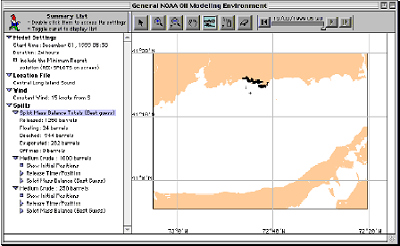
GNOME (General NOAA Operational Modeling Environment) is the oil spill trajectory model used by OR&R Emergency Response Division (ERD) responders during an oil spill.
ESI - Deepwater Horizon Gulf Oil Spill Environmental Sensitivity Index (ESI) Atlases - ESI Viewers are free tools that you can use to view and query Environmental Sensitivity Index (ESI) atlases using the MARPLOT mapping program and a FileMaker application.
GNOME (General NOAA Operational Modeling Environment) is the oil spill trajectory model used by OR&R Emergency Response Division (ERD) responders during an oil spill.
Thursday, April 29, 2010
Free GIS Software Program Download, Page 3 of 9
edbsilon is a converter for data coming in EDBS or BZSN. After reading the EDBS- resp. BZSN-files the converter exports into various format, such as Oracle, PostGIS, ArcGIS Shapefiles and many others.
EPANET - Software That Models the Hydraulic and Water Quality Behavior of Water Distribution Piping Systems.
Erdas Titan 3D Visualization Client - In ERDAS TITAN Client 2010, users may connect to ERDAS APOLLO catalogs via the TITAN Viewer to execute geoprocesses and visualize results in a 3D virtual globe. Descriptive metadata search results from ERDAS APOLLO catalogs are now also available in an easy-to-read display pane. Search and discovery of data in an APOLLO catalog is much faster, due to integration of REST/JSON API.
FGS Linux Installer is a self-extracting file that will install MapServer with PHP/MapScript and all of their dependencies on your Linux system. It provides a stand-alone environment with all the required software (incl. Apache and PHP) to run PHP/MapScript webmapping applications.
FlightGear is an open-source, multi-platform, cooperative flight simulator development project. Source code for the entire project is available and licensed under the GNU General Public License. This is not GIS software but may be of interest to some. Atlas creates free charts of the world for FlightGear.
Flowmap is a software package dedicated to analyzing and displaying interaction or flow data. This type of data is special in the sense that there are two different geographic locations connected to each data item: An origin location where the flow starts and an destination location where the flow ends. The flow data itself can be people (e.g. commuters, shoppers, hospital visitors), goods, usage of agricultural services or telecommunication and so on.
Fusion is a web-mapping application development framework for MapGuide OS and MapServer built primarily in JavaScript.
FWTools is a set of Open Source GIS binaries for Windows (win32) and Linux (x86 32bit) systems produced by me, Frank Warmerdam (ie. FW). The kits are intended to be easy for end users to install and get going with. No fudzing with building from source, or having to collect lots of interrelated packages.
geGIS is an open source platform that allows you to manage your Geo Data using a standard browser. geGIS first and foremost involves the management and exchange of authentic source data between equal servers.
gen2shp is a simple C-Progam which can read the format required by the ESRI ArcInfo generate command.
Gen2shp - Implemented in Avenue, can be directly incorporated into AV projects. Converts 2D or 3D ASCII data from one or more generate format text files to one or more (multi-part) shapefiles. Available as Extension or just Scripts.
Generic Mapping Tools (GMT) is a collection of about 60 UNIX tools that allow users to manipulate (x,y) and (x,y,z) data sets (including filtering, trend fitting, gridding, projecting, etc.) and produce Encapsulated PostScript File (EPS) illustrations ranging from simple x-y plots through contour maps to artificially illuminated surfaces and 3-D perspective views in black and white, gray tone, hachure patterns, and 24-bit color. GMT supports 30 common map projections plus linear, log and power scaling, and comes with support data such as coastlines, rivers, and political boundaries.
GEO/Garnix free coordinate conversion and GPS communication tools.
geocoder.us / geocoder.net - find the latitude & longitude of any US address - for free
Download MapCruzin.com free GIS software programs
EPANET - Software That Models the Hydraulic and Water Quality Behavior of Water Distribution Piping Systems.
Erdas Titan 3D Visualization Client - In ERDAS TITAN Client 2010, users may connect to ERDAS APOLLO catalogs via the TITAN Viewer to execute geoprocesses and visualize results in a 3D virtual globe. Descriptive metadata search results from ERDAS APOLLO catalogs are now also available in an easy-to-read display pane. Search and discovery of data in an APOLLO catalog is much faster, due to integration of REST/JSON API.
FGS Linux Installer is a self-extracting file that will install MapServer with PHP/MapScript and all of their dependencies on your Linux system. It provides a stand-alone environment with all the required software (incl. Apache and PHP) to run PHP/MapScript webmapping applications.
FlightGear is an open-source, multi-platform, cooperative flight simulator development project. Source code for the entire project is available and licensed under the GNU General Public License. This is not GIS software but may be of interest to some. Atlas creates free charts of the world for FlightGear.
Flowmap is a software package dedicated to analyzing and displaying interaction or flow data. This type of data is special in the sense that there are two different geographic locations connected to each data item: An origin location where the flow starts and an destination location where the flow ends. The flow data itself can be people (e.g. commuters, shoppers, hospital visitors), goods, usage of agricultural services or telecommunication and so on.
Fusion is a web-mapping application development framework for MapGuide OS and MapServer built primarily in JavaScript.
FWTools is a set of Open Source GIS binaries for Windows (win32) and Linux (x86 32bit) systems produced by me, Frank Warmerdam (ie. FW). The kits are intended to be easy for end users to install and get going with. No fudzing with building from source, or having to collect lots of interrelated packages.
geGIS is an open source platform that allows you to manage your Geo Data using a standard browser. geGIS first and foremost involves the management and exchange of authentic source data between equal servers.
gen2shp is a simple C-Progam which can read the format required by the ESRI ArcInfo generate command.
Gen2shp - Implemented in Avenue, can be directly incorporated into AV projects. Converts 2D or 3D ASCII data from one or more generate format text files to one or more (multi-part) shapefiles. Available as Extension or just Scripts.
Generic Mapping Tools (GMT) is a collection of about 60 UNIX tools that allow users to manipulate (x,y) and (x,y,z) data sets (including filtering, trend fitting, gridding, projecting, etc.) and produce Encapsulated PostScript File (EPS) illustrations ranging from simple x-y plots through contour maps to artificially illuminated surfaces and 3-D perspective views in black and white, gray tone, hachure patterns, and 24-bit color. GMT supports 30 common map projections plus linear, log and power scaling, and comes with support data such as coastlines, rivers, and political boundaries.
GEO/Garnix free coordinate conversion and GPS communication tools.
geocoder.us / geocoder.net - find the latitude & longitude of any US address - for free
Download MapCruzin.com free GIS software programs
Tuesday, April 27, 2010
Free and Open Source MapCruzin GIS Mapping Software Program Applications - Geocoding, Geodas, GeoPublisher ... More, Page 4 of 9
Geocoding - Map Channels offers free single address and batch geocoding.
GEODAS (GEOphysical DAta System) data management system can be run in Microsoft Windows, UNIX Xwindows and Macintosh OS-X environments. GEODAS software accesses all GEODAS Databases, including Marine Trackline Geophysics, NOS Hydrographic Surveys, Coastal Relief Model, ETOPO2 Gridded Elevations and Great Lakes Bathymetry DVD sets.
Geodetic software developed by the National Geodetic Survey (NCS). Free downloads - dozens of programs.
Geographic Foundation Class (GFC)Library is a set of C++ classes defining basic geographic data types, including points, lines, rectangles, circles, polylines, rings, complex polygons, rasters, and other atomic data types such as integer, real, varchar. GFC also features abstractions of timestamps and time series which are useful in capturing the dynamics of spatiotemporal data.
Geopublisher Software allows you to quickly create digital multimedia atlases and publish them. Visit the demo atlases page to take a look at some publically available atlases or check out the features list to get an impression about the possibilities.
GeoServer - GeoServer is an Open Source server that connects your information to the Geospatial Web. You can publish and edit data using open standards. Your information is made available in a large variety of formats as maps/images or actual geospatial data.
Geospatial Explorer has been written to enable geologists, environmental scientists, and engineers to apply innovative science and technology to enhance and expedite the reduction of risk to human health and the environment. Geospatial Explorer permits the user to identify, understand, and solve complex environmental problems better, faster, and cheaper.
Geographic Translator (GEOTRANS) is an application program which allows users to easily convert geographic coordinates among a wide variety of coordinate systems, map projections, and datums. GEOTRANS runs in both Microsoft Windows (95/98/NT) and UNIX Motif environments.
geos (Geometry Engine Open Source (GEOS)) is a C++ port of the Java Topology Suite (JTS). As such, it aims to contain the complete functionality of JTS in C++. This includes all the OpenGIS "Simple Features for SQL" spatial predicate functions and spatial operators, as well as specific JTS topology functions such as IsValid().
GeoTools is Java code library which provides standards compliant methods for the manipulation of geospatial data, for example to implement Geographic Information Systems. The GeoTools library implements OGC specifications as they are developed, in close collaboration with the GeoAPI and GeoWidgets projects.
GeoVISTA Studio is an open software development environment designed for geospatial data. Studio is a programming-free environment that allows users to quickly build applications for geocomputation and geographic visualization.
GeOxygene aims at providing an open framework which implements OGC/ISO specifications for the development and deployment of geographic (GIS) applications.
GIS ObjectLand is a universal Geographic Information System for Windows. It processes data organized as geoinformation database (GDB). Basic GDB components are maps, themes, tables, queries, external databases, layouts, users, and styles. Free non-commercial license.
Download Free MapCruzin.com GIS Software Programs
GEODAS (GEOphysical DAta System) data management system can be run in Microsoft Windows, UNIX Xwindows and Macintosh OS-X environments. GEODAS software accesses all GEODAS Databases, including Marine Trackline Geophysics, NOS Hydrographic Surveys, Coastal Relief Model, ETOPO2 Gridded Elevations and Great Lakes Bathymetry DVD sets.
Geodetic software developed by the National Geodetic Survey (NCS). Free downloads - dozens of programs.
Geographic Foundation Class (GFC)Library is a set of C++ classes defining basic geographic data types, including points, lines, rectangles, circles, polylines, rings, complex polygons, rasters, and other atomic data types such as integer, real, varchar. GFC also features abstractions of timestamps and time series which are useful in capturing the dynamics of spatiotemporal data.
Geopublisher Software allows you to quickly create digital multimedia atlases and publish them. Visit the demo atlases page to take a look at some publically available atlases or check out the features list to get an impression about the possibilities.
GeoServer - GeoServer is an Open Source server that connects your information to the Geospatial Web. You can publish and edit data using open standards. Your information is made available in a large variety of formats as maps/images or actual geospatial data.
Geospatial Explorer has been written to enable geologists, environmental scientists, and engineers to apply innovative science and technology to enhance and expedite the reduction of risk to human health and the environment. Geospatial Explorer permits the user to identify, understand, and solve complex environmental problems better, faster, and cheaper.
Geographic Translator (GEOTRANS) is an application program which allows users to easily convert geographic coordinates among a wide variety of coordinate systems, map projections, and datums. GEOTRANS runs in both Microsoft Windows (95/98/NT) and UNIX Motif environments.
geos (Geometry Engine Open Source (GEOS)) is a C++ port of the Java Topology Suite (JTS). As such, it aims to contain the complete functionality of JTS in C++. This includes all the OpenGIS "Simple Features for SQL" spatial predicate functions and spatial operators, as well as specific JTS topology functions such as IsValid().
GeoTools is Java code library which provides standards compliant methods for the manipulation of geospatial data, for example to implement Geographic Information Systems. The GeoTools library implements OGC specifications as they are developed, in close collaboration with the GeoAPI and GeoWidgets projects.
GeoVISTA Studio is an open software development environment designed for geospatial data. Studio is a programming-free environment that allows users to quickly build applications for geocomputation and geographic visualization.
GeOxygene aims at providing an open framework which implements OGC/ISO specifications for the development and deployment of geographic (GIS) applications.
GIS ObjectLand is a universal Geographic Information System for Windows. It processes data organized as geoinformation database (GDB). Basic GDB components are maps, themes, tables, queries, external databases, layouts, users, and styles. Free non-commercial license.
Download Free MapCruzin.com GIS Software Programs
Monday, April 26, 2010
MapCruzin Free Natural Disaster ArcGIS Shapefile Map Layer Series
U.S. Dams and Risk, U.S. Earthquakes 1568 - 2004, Hurricanes Making Landfall in U.S., World Volcanoes
U.S. Dams ArcGIS Shapefile - This map layer portrays major dams of the United States, including Puerto Rico and the U.S. Virgin Islands. The map layer was created by extracting dams 50 feet or more in height, or with a normal storage capacity of 5,000 acre-feet or more, or with a maximum storage capacity of 25,000 acre-feet or more, from the 79,777 dams in the U.S. Army Corps of Engineers National Inventory of Dams. Includes dam name, location, type, size and associate risk level ... Download
Significant United States Earthquakes 1568 - 2004 - The National Earthquake Information Center (NEIC) manages, disseminates, and archives earthquake information. The NEIC is part of the Earthquake Hazards Program at the U.S. Geological Survey (USGS). The NEIC focuses its efforts on mitigating the risks of earthquakes to mankind. Toward this goal, the NEIC works to determine the location and size of all destructive earthquakes, pursues an active earthquake research program, and collects and provides an extensive earthquake database that serves as a solid foundation for scientific research to scientists and to the public ... Download
Hurricanes Making Landfall in U.S. - This Historical North Atlantic Hurricane Tracks file of major storms with landfall in the United States contains the six-hourly (0000, 0600, 1200, 1800 UTC) center locations and intensities for all northern Atlantic major storms from 1851 through 2004. Major storms are those that made landfall in the United States and that were classified on the Saffir-Simpson Hurricane Scale as Category 3, 4, or 5 at the time of landfall ... Download
Volcano ArcGIS Shapefile - The large and growing Volcanoes of the World database developed by the Global Volcanism Program of the Smithsonian Institution contains the geographic, historical, and volcanological characteristics of nearly 3,000 active volcanoes around the world ... Download
Download MapCruzin Natural Disaster Shapefiles
U.S. Dams ArcGIS Shapefile - This map layer portrays major dams of the United States, including Puerto Rico and the U.S. Virgin Islands. The map layer was created by extracting dams 50 feet or more in height, or with a normal storage capacity of 5,000 acre-feet or more, or with a maximum storage capacity of 25,000 acre-feet or more, from the 79,777 dams in the U.S. Army Corps of Engineers National Inventory of Dams. Includes dam name, location, type, size and associate risk level ... Download
Significant United States Earthquakes 1568 - 2004 - The National Earthquake Information Center (NEIC) manages, disseminates, and archives earthquake information. The NEIC is part of the Earthquake Hazards Program at the U.S. Geological Survey (USGS). The NEIC focuses its efforts on mitigating the risks of earthquakes to mankind. Toward this goal, the NEIC works to determine the location and size of all destructive earthquakes, pursues an active earthquake research program, and collects and provides an extensive earthquake database that serves as a solid foundation for scientific research to scientists and to the public ... Download
Hurricanes Making Landfall in U.S. - This Historical North Atlantic Hurricane Tracks file of major storms with landfall in the United States contains the six-hourly (0000, 0600, 1200, 1800 UTC) center locations and intensities for all northern Atlantic major storms from 1851 through 2004. Major storms are those that made landfall in the United States and that were classified on the Saffir-Simpson Hurricane Scale as Category 3, 4, or 5 at the time of landfall ... Download
Volcano ArcGIS Shapefile - The large and growing Volcanoes of the World database developed by the Global Volcanism Program of the Smithsonian Institution contains the geographic, historical, and volcanological characteristics of nearly 3,000 active volcanoes around the world ... Download
Download MapCruzin Natural Disaster Shapefiles
Subscribe to:
Posts (Atom)


