Wednesday, March 30, 2011
All Things Nuclear
View and Download All Things Nuclear
Sunday, March 27, 2011
Heavy Flooding Coming to California and Nevada?

Check NOAA's California and Nevada River Flood Center Maps
Mike
Free GIS Shapefiles, Maps, Tutorials and Software
Tuesday, March 22, 2011
Updated Nuclear Facilities in the U.S. Maps, Shapefiles and Images - Download Free
After examining lists in various reports and at government and NGO websites, I've determined that as of March 2011 there are 65 operating nuclear power facilities in the U.S. Each facility has from 1 to 3 reactors for a total of 104. This number does NOT account for those reactors that are decommissioned, reactors at research and university facilities or all of the nuclear waste at various locations around the United States. In time, I will make shapefiles available of these other nuclear hazards. See below for an updated nuclear and seismic hazards shapefile and spreadsheet that you may download and use as you wish.
Here's the new map based on this updated data:

For now, you can download an updated shapefile and speadsheet that shows all of these nuclear reactors that are currently operating in the U.S.
Also, I've added some map images in PNG, TIF and Acrobat PDF formats that you may download and use as you see fit.
Download the U.S. Nuclear Facility and Seismic Hazards Shapefiles, Maps and Images
Monday, March 21, 2011
How many nuclear power plant reactors are there in the United States?
Note that if you look at the current spreadsheet or shapefile that you may download from this page, you will find several other types of nuclear related facilities besides Nuclear Power Plants. In the future, I'd like to also list and document all the non-energy related reactors that are in operation at national laboratories, universities, hospitals, research firms and elsewhere. Beyond that it is also important to document decommissioned nuclear power plants and other places that nuclear waste is currently stored.
View and download the nuclear power plant and seismic hazards shapefiles and spreadsheet
Thursday, March 17, 2011
Maps of Nuclear Reactor Power Plants of the World

Find nuclear reactor power plants around the world
Wednesday, March 16, 2011
Can a Fukushima Like Nuclear Accident Happen in the United States?
Download the nuclear facility spreadsheet and shapefiles here.
Tuesday, March 15, 2011
Free U.S. Seismic Hazard, Historical Earthquakes and Nuclear Reactor Power Plant ArcGIS Shapefiles
I have provided some sample maps. I created these with Maptitude GIS. If you are new to GIS, check out our Learn2Map GIS Tutorial and Atlas, learn more and download a free GIS program that you can use to make your own maps with these shapefiles.
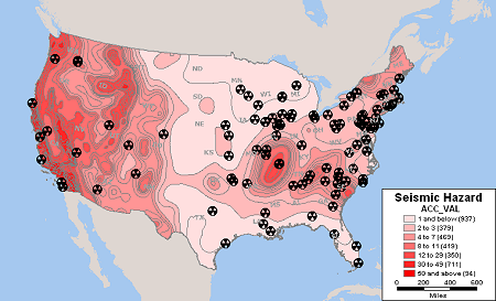
Nuclear Facilities and Seismic Hazard Zones
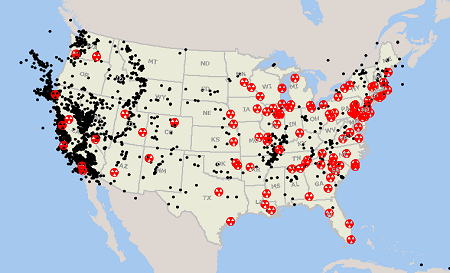
Nuclear Facilities and Historical U.S. Earthquakes
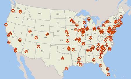
Nuclear Reactors in the United States
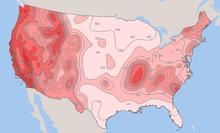
U.S. Seismic Hazard Zones
Download U.S. Nuclear Reactor, Historical Earthquakes and Seismic Hazard Shapefiles
Saturday, March 12, 2011
Japan Tsunami Maps and Shapefiles
Tuesday, March 8, 2011
TIGER/Line 2010 Census Redistricting (P.L. 94-171) ArcGIS Shapefile
Download TIGER/Line Shapefiles
Visit MapCruzin.com for Free GIS Software Programs, Shapefiles, Maps, and Tutorials
Thursday, March 3, 2011
2010 Census Redistricting [P.L. 94-171] Data and Shapefile Availability
The technical documentation for the 2010 Census Redistricting [P.L. 94-171] TIGER/Line Shapefiles can be accessed here.
The following redistricting data files (2010 population and housing characteristics) are now available from the American Factfinder:
Alabama
Arkansas
Colorado
Delaware
Hawaii
Illinois
Indiana
Iowa
Kansas
Louisiana
Maryland
Mississippi
Missouri
Nebraska
Nevada
New_Jersey
North_Carolina
Oklahoma
Oregon
South_Dakota
Texas
Visit MapCruzin.com for Free GIS Software Programs, Shapefiles, Maps, and Tutorials
Take a Ride with Trimble Mobile Mapping
Trimble Mobile Mapping
Visit MapCruzin.com for Free GIS Software Programs, Shapefiles, Maps, and Tutorials
Nevada Geographic Information Society Annual Conference, Reno, Nevada
The 2011 Annual Conference theme is "GIS At Your Service". This is a particularly apt theme, as geographic information systems have expanded in to every facet of public life. From routine commerce to personal navigation, to emergency services, geographic information systems have become an integral part of the fabric of our society. Once the province of a few experts, geographic data systems are now so ubiquitous that it is taken for granted. The 2011 conference will showcase many of the services that GIS provides and give us all a glimpse of many such services that lie just over the horizon. See the link on this page to get more conference information, to register, and to submit papers and session plans.
More information and to register for the NGIS 2011 Conference
Visit MapCruzin.com for Free GIS Software Programs, Shapefiles, Maps, and Tutorials

