
geGIS is an open source platform that allows you to manage your Geo Data using a standard browser.
How does geGIS work?
The geGIS architecture is obviously perfectly in keeping with the vision reflected in the geGIS concept, which may be summed up as follows:
- Creating an ecosystem of servers for exchanging authentic source data over the Internet on an open and standard basis
- Using this ecosystem as a medium for a new generation of geowindows based on high-performance Web 2.0 technology
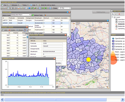
geGIS first and foremost involves the management and exchange of authentic source data between equal servers. geGIS operates on the basis of the fact that myriad organisations are now compelled to entrust the actual administration of their data with so-called GIS "specialists". Our basic philosophy is that every IT organisation should be able to manage and exchange its own geodata. This calls for an architecture that differs drastically from Google Maps, for example, for which solely one central data manager is available. The exchange of geodata on equal terms is possible solely via a process of standardisation, thanks to the open GIS standards of the Open Geospatial Consortium. As well as putting these standards into practice geGIS forges further ahead: the layers developed may be deployed straightaway in a public geowindow.

Learn More and Download geGIS.
I Hope this proves to be useful for you. If you are new to GIS, check out the Learn2Map GIS Tutorial and Atlas. We have more free GIS software available and there is plenty of free data and shapefiles that will work with these programs. More to come!


No comments:
Post a Comment